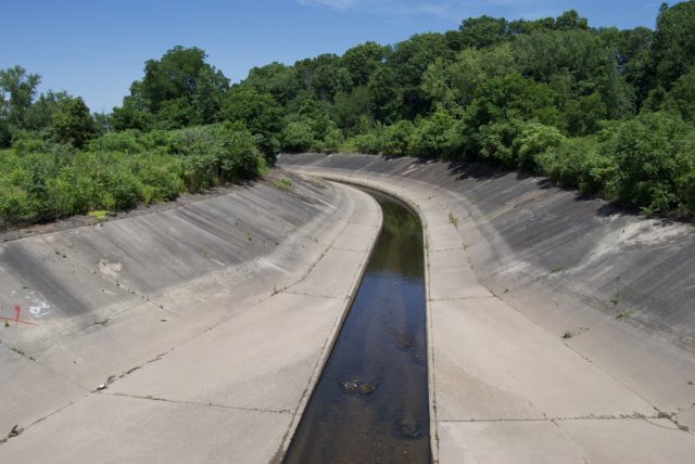
The Park River continues to intrigue, mainly because so much of it has been buried below the city. I am working on a project to help distinguish between rumors, legends, misconceptions passed along as fact, and actual facts.
While the writing process is ongoing, I have and will continue to be sharing information about the Park River and its watershed on a map.
This is meant to answer basic questions, but to provoke many more.
What was, is, and will be our relationship with the natural world? When does nature stop being nature? Can we build a time machine, go back, and sucker punch those who thought that expansion of real estate and development of oversized highways was worth losing our connection to nature? Why does anyone think they can own water? What is access, anyway? To think about a river requires thinking about networks.
This is a living map. Content will continue to be added. As of publication, you will see a lot about the Park River. The next phase will be the addition of material about its tributaries.
LEGEND
How do you read the map? On the left is a column that provides background, and then layers. Currently, there are two layers: General Information and Drowning Deaths. If you are interested in only one, click off the layer you do not want to see. Another way to read the map is by zooming in on the map, then clicking on various pins. These are color coded by subject.
Places where there is potential access to the river are marked (red/raspberry pins), though some might be considered private property and I did not tell you to trespass. What is access? Is it simply a view? A path? A paved path? Do you require neon signs pointing from all directions? I tend to think that access can be either a trail or a scenic overlook. Between my notes and zooming in on the map, you can usually tell if there is some kind of path to be had.
Various views of the river are included (blue pins).
Orange pins denote historical happenings in and around the river, from tales of fish gone wild from being poisoned, to politicians asking to have the river covered in parts because they wanted more surface parking in downtown Hartford. In many cases, these are approximate locations. More on that later.
The pins that are green trees show flora. I did not mark every single appearance of every plant. These are here to give an idea of what can be found on and near the river banks. Not all plants are edible.
The pins that are brown paws show pictures of fauna, or indicate what types of wildlife have been spotted.
Artistic endeavors across time are marked by purple pins. The locations are either where the artist found inspiration, created the work, or put it on display.
The purple swimmer pin is for “Fun & Games” — naughty and generally harmless incidents.
Additionally, there is a layer devoted to deaths by drowning. Although this may appear dramatic and overwhelming, it is important to note that these were not drownings over the course of one generation. These are what have been recorded since the Europeans settled Dutch Point. There are details that have no doubt been lost to history. This information is as accurate as possible. Most of the information has been summarized from various newspaper accounts, but I have directly quoted when it felt necessary. Our norms have certainly changed when it comes to providing personal details in news accounts; for this reason, I have declined to provide the names of individuals involved in police chases and so forth if it is possible that they are still alive, even though their names were published when the incident happened. There were some newspaper accounts that used language that is considered offensive by today’s standards; occasionally I used this language, quoting directly, to remind viewers of what people in a supposedly liberal city within a supposedly liberal state thought was acceptable even as recent as a few decades ago.
As you look at the drowning deaths, keep in mind that autopsies were not always performed, so it is more accurate to call these “presumed drownings.” You’ll see that in many cases, those who drowned had been sleeping in the park and rolled down an embankment, or fallen off their veranda. Did they drown or die from head injuries? A little of both? I included suicides in the mix as well, because it’s not always certain if a person intended to drown, and in some cases, a victim might change their mind after jumping. In cases where a death was reported in/beside the river but was clearly the result of something other than drowning, the details were included in a History Note instead of this layer.
It’s easy to be shocked and think that covering the river was the right thing to do for the protection of residents, but it is important to look at details and pay attention to trends. Almost all of these deaths could have been prevented, either by sobriety, better parental supervision, or using better judgement about walking on an icy river. Without even doing the math, it appears that there was an average of one related to drowning, per year. Compare this to how many per year died from smallpox or the flu, or today, how many die as the result of car crashes and drug overdoses.
Final note: I have made every attempt to be accurate with the location of the pins. Records are sometimes vague (“in the Park River”) or (“above the screw company dam”). Outdated references are given, requiring research into what a building was used as in a particular era, and where that might be today, which with the covering of the river, moving of it, and constructing highway all around it, can be quite the task. One source even described an area as being known as “the bee-hive,” but who called it this, I cannot say. I was not able to find any other reference. Was it a bee hive of activity, shaped like a bee hive, or something else? For that, I looked at the areas closest to the victim’s home and where the river potentially looked like a hive.
SUGGESTIONS?
With that said, as new information comes to light, adjustments will be made for accuracy.
If there is something that should be included here, send an email to kerri.provost@gmail.com with subject: Mapping the Park River.
Tim
Fantastic job. I really appreciate your effort and the breadth of the research that went into this. The map really enriches one’s appreciation of this winding waterway that many have come to not see, even when it’s before our own eyes. Just spent a good 30 minutes clicking away and making discoveries. Thanks.
Steve Thornton
This is an extraordinary history!