If you’ve been in Hartford for five minutes, you’ve likely heard the widely accepted narrative: Hartford suffered two major floods in 1936 and 1938; because of this, it became necessary to alter the Park River’s course and shove it into a conduit. And anyway, it stank, so nobody was going to miss it.
This explanation has been provided by all the mainstream media — along with politicians and various planners — with little variation over the last several decades.
What if that oft-repeated story is misleading? What if the floods are not the whole story?
If you dig into old copies of the Hartford Courant, you find there was a push to contort and delete the river long before the devastating floods, and this push was largely driven by Herbert S. Swan, a city planning and zoning “expert” out of New York who seemed hostile toward parklands and the natural world, or at least those standing in the way of highway construction and road widening.
These old Hartford Courant pieces create a timeline that drifts from what most of us have heard parroted as common knowledge:
1911 Hartford Courant: An article from December detailed possible plans to cover the Park River from the Connecticut River to Hamilton Street: “aside from hiding the river from view, [an advantage] would be the gain in territory for building and highway purposes.” The plan to cover this portion of the river was rejected because of the cost, along with “unhealthful conditions” that would arise from “gases,” and “possible damage from excessive floods.” To put it more clearly, in 1911, flooding was stated as a reason to not cover the Park River from Frog Hollow to the Connecticut River. Hmm…
1926 Hartford Courant: Herbert S. Swan’s vision is published without question. The article states that “Glacial erosion laid the foundation for Hartford’s traffic problem,” which assumes traffic to be a problem. The paper reads: “Parks and cemeteries, in the opinion of Mr. Swan, are a handicap for Hartford traffic.” At this time, Swan wanted a road parallel to the railroad, but sees the Park River, along with park land, as an obstacle to this.
1926 Hartford Courant: In this piece, “Mr. Swan recommends a 72-foot roadway, necessitating either shifting the location of the Park River or putting it in a conduit.”
1928 Hartford Courant: Swan predicts that Hartford’s population will be 525,000 in 1980, and said “the Park River should be flumed and transformed into a thoroughfare which will divert eastbound traffic from the heart of the city.” Swan insists that Hartford must widen its streets. He called Bushnell Park a “distinct traffic disruption.”
1935 Hartford Courant: This piece calls for burying the Park River, first for beautification, then to “prevent flooding of cellars on Asylum Street and on Jewell Street.” This fairly minor flooding concern appears to be the first one named in connection with any move to cover the river.
There is a major flood in March 1936 when it rains constantly for two weeks.
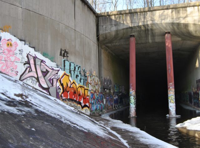
Following the hurricane, another major flood occurs in 1938. This is Connecticut’s worst documented natural disaster. Work on the first conduit begins at the end of 1938.
1941 Hartford Courant: Thirty years after Swan’s call to cover the Park River, the conduit work was underway: “To hold the river it was necessary to build a double conduit. . . . Because a highway is to run on top of these conduits it was necessary to design them so they could withstand both internal and external pressures.”
The paper went on to say that “The part [of the conduit that] Hartford people will see and appreciate every day will be the four lane highway which will be constructed on top of the conduits. This road will connect with the thorough highways which will top Hartford’s new dikes and join the new Connecticut River bridge and the Wilbur Cross Highway […] Throughout its course it will have no intersections. […] All these plans have been made so it will inconvenience Hartford motorists as little as possible.” There was more inky praise given for the highway than for prevention of future floods.
In 1971 the U.S. Army Corps of Engineers advocated for a final burial with the creation of another conduit. Here is a piece of their justification for it as seen in their report: “As related to a natural environment, the impacts would be negative, because the Park River is already partly enclosed in conduits, because only minimal vestiges of a natural environment remain, and because no possibility exists that the urbanization process can be reversed and a natural environment restored. As related to the existing urban environment, the impacts would be positive and beneficial. The auxiliary conduit would be installed almost completely under existing streets, Park Street and Wyllys Street. The connecting sections of conduit (3,716 feet) would eliminate the reaches of now open channel, eliminating the low aesthetic and high hazard characteristics of these reaches.”
Work on an auxiliary conduit began in 1976. Courant articles from 1980 and 1981 applauded the gain in surface parking resulting from covering the Park River. One of those pieces reads: “The river work has given birth to two other plots — one between Broad and Flower Streets and another between Flower Street and an I-84 overpass. The new acreage is earmarked for conversion to parking lots. The Courant at 285 Broad St. has expressed an interest in leasing both lots for parking.”
In recent years, various folks have advocated “reclaiming” the river, or to steal from the engineers, reversing the urbanization process. That this is has been up for discussion — financial feasibility aside — suggests something amiss about the flood prevention narrative.
Wilson H. Faude, in a 2006 issue of the Hartford Courant, may have written the only piece that dared call this narrative a sham. In it, he alleged that floodgates would have sufficed, but the river burial was never about preventing flooding. . . it was always about moving cars through Hartford without delay.
As Faude wrote: “Under the guise of flood control, the city received approval of the plan to bury the Park River. When the mountains of dirt created by the project obscured all views of the park, the city took park land and Park River bed and built streets in their place. It happened without public notice or objection. The bridge beneath the Soldiers and Sailors Memorial Arch was shortened by over 60 feet. The multispan Hoadley Bridge was reduced to a plaque.The single-lane road that once bordered the park on its north and east side (Ford, Jewell and Wells streets) was widened to six lanes, in part, with islands in the middle! At the railroad bridge on Asylum, more land was taken to form a multilane thoroughfare, complete with bus pull-offs.”
As Faude wrote, “In other words, the Park River was never the problem, but by burying it, the city could solve its road issues.”
Or, to use Herbert Swan’s own words in a piece published by the Oneonta Star: “The community that does not think enough of the future to plan for it will soon not have enough of a community to plan for.”
Tom McCudden
Very interesting. I wonder how the planned highway went from “Throughout its course it will have no intersections” to “let’s have a bunch of on and off ramps on both sides of the highway.”
Kerri Provost
Right?! Add to that “let’s all be super mad about people driving slow in the left lane, but also have curvy entrance ramps that dump people in the left lane”
mary pelletier
Once again the City and Ct DOT planners are focused on solving their road building interests by burying one of the last – yet most significant trace of the Park River within Bushnell Park, the 650′ curved Stony Creek granite wall, which carries the train tracks over Asylum Avenue are slated for demolition by the I-84 so that there will be a new road, “Toni’s Road” between Capital and Asylum Avenues. The logic is that by wiping out the quiet footpath along the edge of this monumental wall (that has never been cleaned) for a 4 lane road that will combine the Capital and Asylum on-off ramps into one that will be oriented directly behind the Bushnell Park stage (so that the audience will be facing the stage + the commuter trafficway) Hartford will be more walkable. Stunning how transportation planners continue to dominate decisions that in other cities have been recognized as the opportunities for landscape and urban design (rather than spending millions to tweak highways and adding more roads)
Kerri Provost
Well said, Mary! I was thinking of you while researching and writing this. We need more advocates for natural spaces, even those that were deemed useless because nothing bigger than a canoe could use them.
Phil Augur
Excellent article –thanks for the information!!!
Richard A. Rakus Sr
It is as if these so called urban planners can’t find enough ways to remove whatever charm is left in the city of Hartford.