Instead of screaming into the void of Twitter, I bring you a weekly highlight reel of what it’s like going places in Greater Hartford when one is gloriously car-free. These posts are on a slight time delay because nobody needs to know exactly where I am when I am there.
HOW ARE YOU DOING?
I would like to revise my answer.
Recently, I was asked what question I am most frequently asked, in the context of not having a car, but later it dawned on me that it’s the question we are probably all insincerely asked: how are you?
Half-jokingly, I made a New Year’s Resolution to answer that question honestly when asked by people too lazy to try harder with conversation. I’ve failed to fulfill that even once, but I will keep making the effort.
How are you?
Just walked through the site of someone’s recent violent death.
There is windshield glass stuck in the sole of my shoe.
Over one week later, the glass remains scattered on the sidewalk.
How are you?
Simmering with trauma.
How are you?
Disgusted with the absence of political will to change dangerous conditions, knowing that the government and its players will cry poor, yet find the money when it comes to harassing people for loitering and panhandling. Hartford police managed to find resources to make 88 adult arrests for panhandling between January 1 through March 31, 2022. But money to make our most dangerous roads safer?
How are you?
Raging that the City of Hartford is pumping its energy into a watered down open streets scheme when it could be improving street design.
How are you?
About to backhand the next person who suggests that hi-vis clothing is the solution when we don’t mandate vehicles be painted in neon colors. I could walk down the street naked, wearing nothing but a garland of fairy lights, and someone would nearly run me down, shouting a fake ass apology out the window about how he “didn’t see” me.
These crashes are predictable.
Spend time as a pedestrian. Not just walking two blocks to the food truck downtown. Like, go half a mile, alone. Walking in a large group defeats the purpose.
Walk in areas designed to move people — particularly, non-residents — in and out of the city as quickly as possible.
Two days before the fatal crash at Farmington and Sigourney, I was walking home at lunch and narrowly missed just down the block from there, at Sigourney and Hawthorne. There is a slip lane here because it’s super important that nearby employees get out of Hartford and onto the Interstate ASAP.
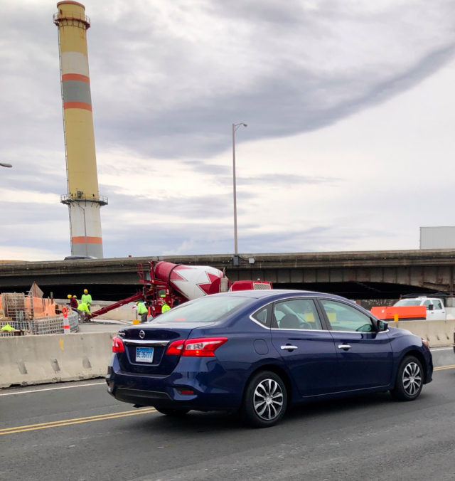
The photo below shows the vehicle that was driven stupidly seconds before. The driver chose to blow the stop sign turning south from Hawthorne onto Sigourney Street. I was in middle of crosswalk at time. Right after that near miss, the driver was stopped at light in traffic. They risked my life for no time savings at all. If you can’t see, this is Connecticut plate BE35777.
How am I?
When I am killed by shitty road design and a bad driver, I demand that you all politicize the fuck out of my death. Miss me on the display of bouquets and candles. If I can’t walk down a street without dying, ain’t nobody else gonna get to use that street either. Drop large concrete blocks across the road. Can’t help yourself about those flowers? Get several of those massive flower pots from KNOX. But none of this thoughts and prayers bullshit. And if anyone dares call it an accident, I will return to haunt your dumb ass, and it won’t be cute.
DON’T NEED A DATA MAP TO KNOW WHERE THE PROBLEMS ARE
(But I’m gonna give you one anyway so you can’t pretend to not know, City of Hartford)
Farmington and Sigourney is one of the intersections I walk through multiple times each week as part of my work commute. When I saw there was a fatal crash here, my reaction was “of course there was.” A pedestrian was critically injured in this intersection in 2013; another killed in 1996. It’s where in 2020 someone sped through the intersection, crashing into another vehicle outside the dollar store.
It’s the intersection where I wrote about watching someone take a right turn on red from the left lane when people were using the crosswalk during the exclusive pedestrian phase. It’s where frequent crashes are known, even without looking at spreadsheets and maps, because there is poor maintenance at the southwest corner and debris sits long enough to be noticed.
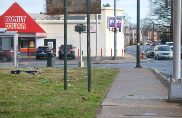
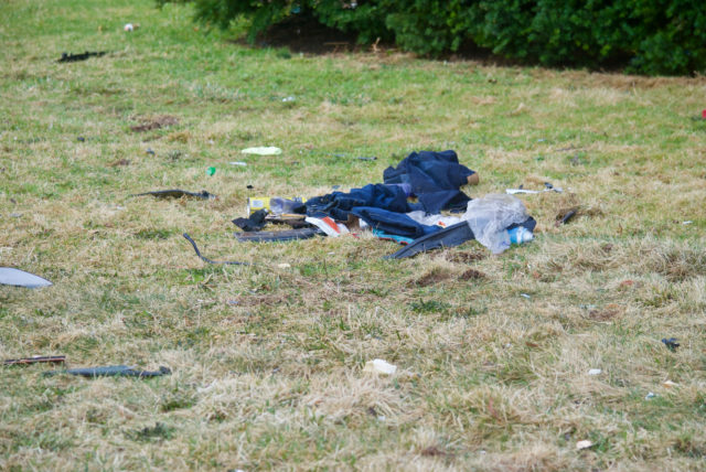
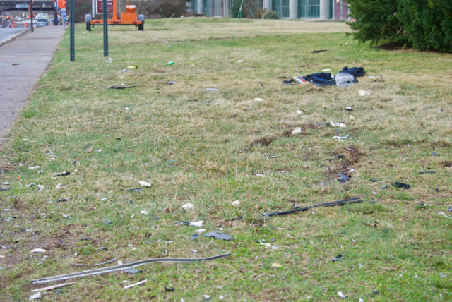
When I walked by the fatal crash site at Farmington and Sigourney, about twelve hours after the preventable death, I was not remotely surprised by the amount of debris allowed to remain — a not-so-subtle reminder that this is outside of one of the city’s more “desirable” neighborhoods. The sidewalk was coated in broken glass. A foot-long piece from one of the cars was on the sidewalk halfway down the block. The lawn was soaked in fluids. What looked like the contents of someone’s trunk or back seat was strewn on the grass. Several 311 reports and over a week later, the broken glass remains.
The car was cleaved by the pole at the corner — at least, that’s what the news photos showed. This is the pole where I stand to press the beg button to get a walk signal, because we are backwards and do not automatically program this at intersections where there are always people waiting to cross.
The thing is, once your eyes are opened to how there are patterns, you can’t close them again. You can’t walk around in some virginal mental state, believing these deaths are one-offs, “accidents.”
Rumor has it, when someone asked the Hartford Complete Streets committee what was going to be done following the recent fatal pedestrian crash in the South Meadows, a City of Hartford employee heading that committee was unaware of this death and suggested studies would need to be done before any action that seems stupidly obvious to those of us who regularly walk or bike, who know the city. You have high speed roads with no sidewalks and suddenly move a population to that area — people who are mostly walking or biking — do you need a study to indicate that if you do nothing else at all, you need to install some damn sidewalks?
I had all of this fresh in mind while repeatedly walking across the broken glass on Sigourney Street the past few days.
Our government — local, and otherwise — acts as if they do not know what is going on, yet they are collecting the data. They have the information. Is their intention to let it gather digital dust?
Bump that.
I’ve decided to make it my goal to strip the government of their excuses for inaction.
The screenshots that follow show crashes with injuries in 2020 and 2021. These are not all the crash sites with injuries in Hartford, only the most frequent ones.
I opted to show this, and not all crashes, because a little dinged bumper is not high priority.
I’ve also opted to omit the Interstate for a few reasons, mainly, that drivers crash their vehicles into other vehicles, or barriers, there, and that these are less to involve bystanders, pedestrians, cyclists, or people’s homes.
All of the crash sites featured are entirely predictable: intersections of roads designed to move vehicles more quickly than is reasonable.
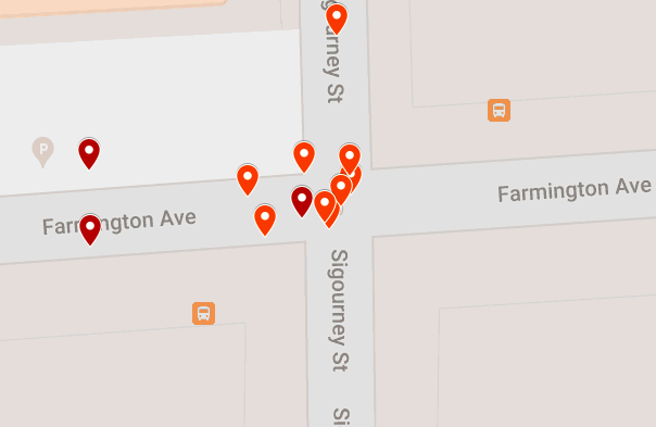
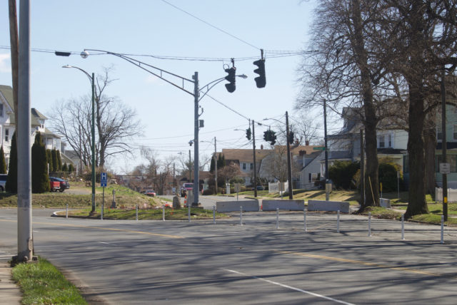
The map above shows crashes with injuries at the intersection of Farmington and Sigourney. That’s eleven collisions resulting in injuries in two years.
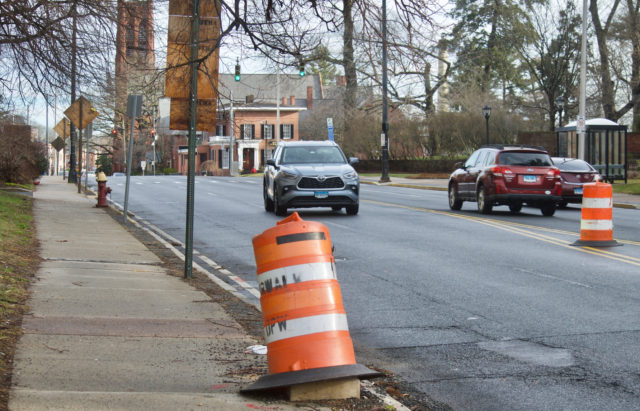
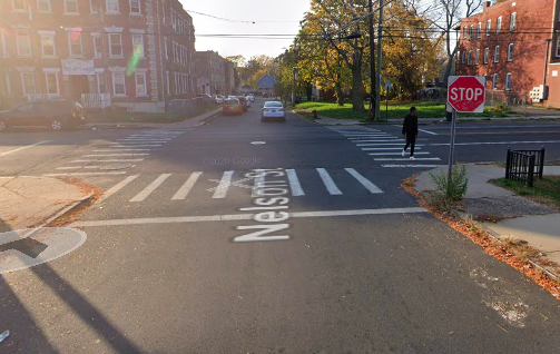
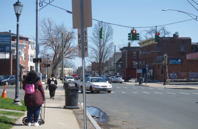
The photo below is of Sigourney Street looking north towards the intersection with Farmington Avenue. It was taken during morning rush hour on Friday, March 25, 2022 — less than twelve hours after the fatal crash at the intersection. From the photo you can see how excessively wide the space is for motor vehicles, and how there is space on both sides for barrier-protected bicycle lanes. You might be asking why we don’t have these here. We’ll get to that another day.
Not mapped: the eleven crashes resulting only in property damage at this intersection in same time period. Crash here, you got a 50/50 shot of being injured.
I know I’m a broken record about this, but imagine if instead of cars, people were injuring themselves and each other with guns at this intersection. This would receive attention. It might not be handled the way we’d like it to, yet there would be acknowledgement of something amiss.
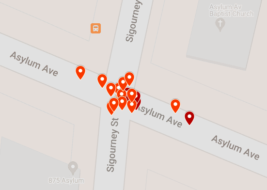
If you travel north, to the next major intersection, the situation is even worse. Look at the cluster. I zoomed in as far as was allowed, and can make out at least 17 crashes with injuries at Asylum Avenue and Sigourney Street. There were three crashes here that only resulted in property damage. Collide with another vehicle here, and you’re going to be injured, basically.
There is a school on one corner. (This is the intersection written about here)
A few years back, they had three crossing guards working this intersection at a time, and even then, drivers blew through the light.
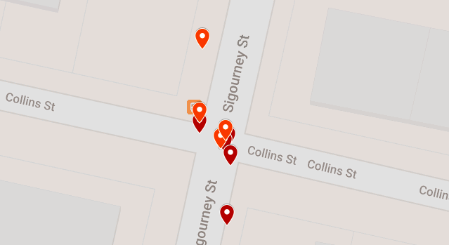
Continue north on Sigourney Street and you’ll soon hit another high crash area: the intersection with Collins Street. There were at least nine crashes with injuries there:
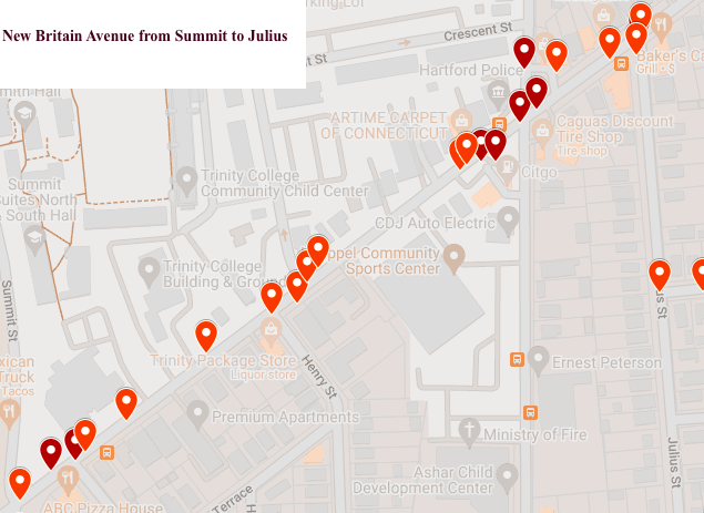
New Britain Avenue is a piece of work. The City could expand the sidewalks on both sides and still have room for protected bike lanes in each direction. They could install raised intersections. A couple roundabouts. They could do a lot of things. For those most part, they’ve done nothing. There are hotspots all over this road, but the area by Trinity College is especially alarming, in part because there are many pedestrians in this area.
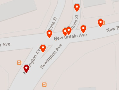
The intersection of Newington Avenue, Stone Street, and New Britain Avenue is not surprising. Newington Avenue is flat and straight; the posted speed limit is 30 MPH which drops to 20 by the intersection, but people drive far faster than that, no matter that there is a school at corner of Newington and New Britain Avenue.
New Britain Avenue is a four lane road. You’ll hear lots of griping about ATVs in this area “holding up traffic,” but it seems traffic could do with more holding up here, as there were ten crashes resulting in injuries at this spot over two years.
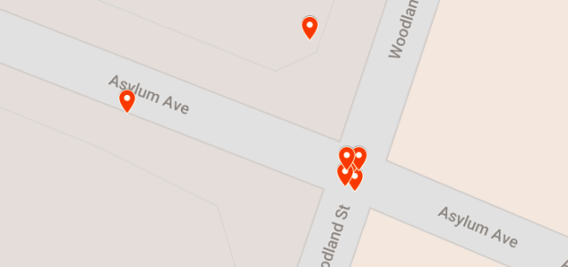
At Woodland and Asylum you have the combination of overly wide roads and frequent red light running. What you’ll find at each corner: middle school, hospital, medical facility, and State of Connecticut building. Some of the collisions here have involved more than two vehicles. At least one was a rollover.
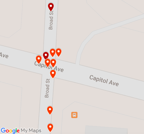
Another obvious problem spot: Capitol and Broad. This intersection was revised a few years to be made worse. Instead of narrowing the intersection, the City of Hartford made it wider. This is where every single Sunday afternoon, without fail, two or more drivers decide to blow through the red light, going eastbound on Capitol Avenue to north on Broad Street — while I’m in the crosswalk.
I’ve watched people drive at highway speeds, particularly going south on Broad Street. This intersection is the poster child for traffic cameras, not only because of the constant violations, but because of the number of times I watch police chillin in their cars at the gas station lot, not stopping anyone for blatant moving violations. When we talk about needing enforcement, let’s make it clear that we’re talking about traffic cameras and not police.
A few blocks south on Broad Street is another cluster. Ten collisions with injuries in two years. There is a library branch on one corner of this intersection. This area enjoys a lot of pedestrian traffic. You do the math on how long before a kid gets seriously injured here.
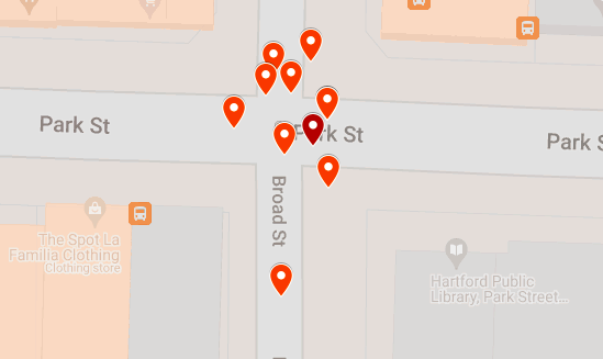
There were another eight crashes at Park and Broad that only resulted in property damage.
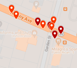
Another serious crash leader is Garden Street and Albany Avenue, with nine crashes resulting in injuries.
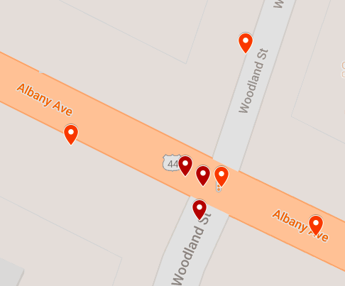
There’s another seven at Albany and Woodland:
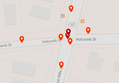
There were eight at Holcomb and Blue Hills:
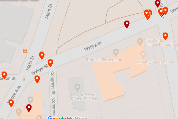
Just as the redesign of Capitol and Broad did not make it noticeably safer, neither did the change at Wyllys and Jefferson, etc. I mapped this intersection with the corresponding disaster of Wethersfield/Main and Wyllys because to me it seems obvious that the same issue exists in both places.
This map shows what looks like sixteen crashes with injuries spread out over these two intersections.
You might be asking yourself why there are a whole lot of serious crashes within one or two blocks of hospitals. The maps immediately above and below show sites within one block of a hospital
Then there’s Main Street and not-so-Pleasant Street, between a school and a stadium.
There’s Pulaski Circle, terribly designed and showing repercussions beyond itself:
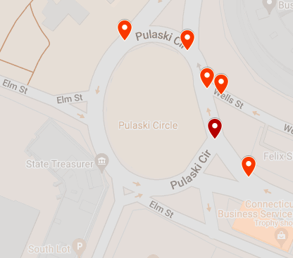 What does that mean? In this area, there are people for whom their entire knowledge of traffic circles is this trash design. Instead of having narrow lanes, there are wide spaces that tell people to go ahead, live fast. Instead of there being sensible rules, like drivers entering circle need to yield to those already in it, the right of way is given to those likely traveling at the fastest speed: those coming off the Whitehead Highway. If you are driving on Wells Street, it’s hard to see who is coming off the ramp unless you pull halfway into the circle. Need to check your adrenalin supply? Do the circle on a bicycle.
Since this poor design is seemingly the only roundabout point-of-reference for many in the area, when they come over to the new roundabout at Russ/Sigourney/Park Terrace, you have people not grasping the concept of yielding to those already in the circle. When the feature first opened in 2021, the initial confusion was awesome. It slowed drivers way down. But now? You get people traveling at high speeds because the redesign did not sufficiently narrow the roadway, and not yielding to pedestrians or to vehicles already in the circle. There is not enough data yet for this site because it has only been open for a few months, but if engineers do not make changes if/when they install the bicycle “facilities,” I will not be at all surprised if it becomes a hot spot.
Already, there have been several crashes (this did not make it into recorded data) resulting in property damage: two newly planted trees were killed on New Year’s Eve. I also had the enjoyment of witnessing a speeding driver blow out his tire. He was too busy and important to stop for me in the crosswalk, and then immediately after passing, he ran into one of the new granite curbs. Pow!
The grassy spaces and sidewalk are continuously covered with hubcaps, bumpers, and other various bits of car debris.
That brings us to Tower and Main, the site of a serious collision that made the news this morning. Two roads designed to enable excessive speeding. Who could’ve seen this coming? Anyone who has spent any time in this area, whether driving, taking the bus, walking, or riding a bicycle — and I’ve gone through this intersection using all those modes. Being on the bus is the only option that feels somewhat safe.
Eight crashes with injuries here in two years.
BUT WAIT, THERE’S MORE
It has not even been a full week since the last fatal motor vehicle crash in the city, and I’m waking up again to hear news of another — this time in the Northeast neighborhood. Later, the story changes. Someone misreported information. As police so callously put it, “the victim has not been pronounced yet.” Yet. Chances are, had it not been for that mistake, we would not have seen news coverage of it. Not for a collision on streets that aren’t used by those commuting in from the suburbs. It would’ve silently appeared in the database as a crash with injuries, known about only by those immediately involved, neighbors, and passersby.
Since 2015, there have been three fatal car crashes on Barbour Street.
That’s the same number as on Albany Avenue for the same period — though 2 of the 3 crashes on Route 44 resulted in dead pedestrians. Chances are you’re more familiar with Albany Avenue than with Barbour Street, and even if you have occasionally driven the latter might be surprised that something seeming so residential would be this dangerous.
Look at the road design:
Looking south on Barbour Street, you see what appear to be reasonably-sized travel lanes…until we remember that paint does not protect and that if there are no cars parked in those empty spaces, it’s going to feel like a wider road, because it is. People drive faster when they feel like they have less to crash into. (Take the construction zone on Sigourney Street. The barriers were arranged to create a wide lane, so you still have people driving excessively fast. Move those barriers in so they only have a couple inches of wiggle room, and you’ll see those speeds drop.)
There’s all this space on Barbour Street marked for parking, but so much of it sits unused. Here’s a free idea for you, City of Hartford: Expand the greenspace and sidewalk on both sides of the street, so that most of the road is physically narrowed. Add street trees. You can leave some of the on-street parking, but I’d suggest 30% of less of what is currently available.
That could be done to so many streets. Start here. Invest in improving a street on which there are multiple schools, a bus route, a mix of residential and retail.
STILL MORE
Again.
Exhausting and predictable.
Another day of waking to read news of a fatal crash.
This one, on New Britain Avenue at Henry Street. 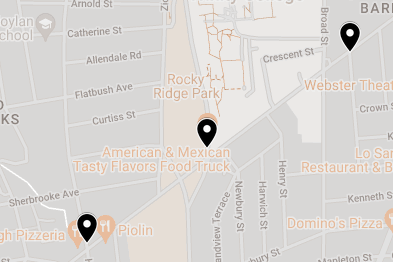
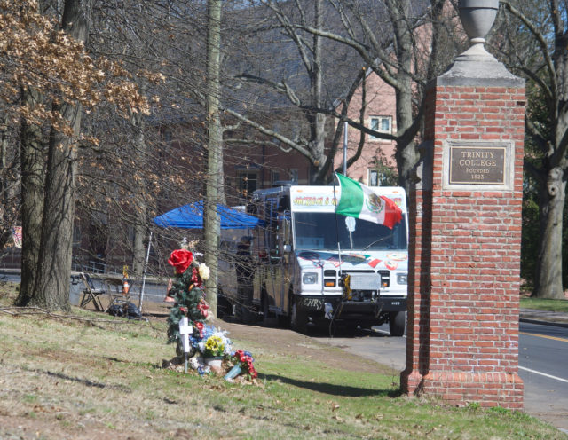
From memory, I knew there had been a fatal crash just a block away. That was a New Year’s Eve (3 AM, so technically, New Year’s Day) wreck, with driver ramming into a brick gate by the Trinity College entrance. That brick decoration, off the roadway, was never rebuilt and there continues to be a shrine.
Looking at the map above, which shows fatal collisions previous to 2022, I can see two other fatal crashes on New Britain Avenue. One from just before 11 PM in the summer of 2019, at the intersection of Julius Street. That’s two blocks east of last night’s crash.
A half mile west of last night’s crash was the site of another 2019 summer fatality. New Britain Avenue and Hillside Avenue. I do not love that I can recall the details of this without prompting. Sharlene Mansfield was crossing the street. Someone was able to — on a clear, dry day just before noon — ram into her because just about every street is built wide enough to accommodate a dump truck or something. The driver was able to operate the vehicle at high speeds, in the wrong lane.
We limit speed on e-scooters but not on cars. We allow sidewalks too narrow for two people to walk side-by-side on, yet have roads where swerving around is possible. Our priorities are messed up, but we get what we build for.
Last night, the roads were wet, but in the vast majority of fatal crashes in Hartford, the roads were dry. There’s hardly any information in the news, but as I’m getting ready for work I keep getting texts from friends all telling me the same thing: the victim is a Trinity College student. A few send me the internal Trinity College email in which this crash is called an accident.
Three young women crossing the street at night.
Women, we are told to walk with buddies so that we are not attacked at night.
Being in a group does not protect against someone speeding down the road, crashing into all of you, and killing one (Jillian Hegarty, 20), critically injuring another (unidentified woman, 19), and causing lesser physical injuries to the third (unidenitfied woman, 20).
That’s a distinction that must be made. The news tells us the nature of physical injuries. How does a person survive this without trauma?
It’s nice that the college is providing counseling to students. They’ll need it as they continue crossing the road where their classmate was run down. Do we talk about that, what it feels like to walk over someone’s death site every day? Many of us have been knowingly doing this already. We might not be young people with wide open futures, but we can tell you how it feels.
We know this will get media attention because the victim is the kind who will get sympathy from a public who generally does not care about pedestrian deaths. That attention does not inevitably create change. We’ve seen several young people killed while walking or cycling on Connecticut’s roads in the last few years, and what followed was typically a show of pitchforks and torches, going after the drivers, and not even well at that. In at least one of those more publicized fatal pedestrian collisions — the one in East Windsor where the town provides no sidewalks — the driver is still allowed to drive!
Two weeks ago, a 69-year old Hartford man was killed when the driver of a garbage truck struck him. In January, Yarillis Esteras, of Hartford, was killed when struck about five minutes from her home. About ten minutes into 2022, Michael Brown of Windsor was killed on Hartford’s streets; the driver of the vehicle that hit him did not remain on the scene.
Most pedestrian deaths go unnoticed. They shouldn’t.
There’s the “well, what then?” question I have been trying to answer.
Take the sadness or rage or disgust or disappointment you feel over a young person getting killed and hold that when you hear about any person getting killed. . . multiply that. Do something with it. Thoughts and prayers are not enough.
Yes, you.
Let the grieving families mourn without expecting them to spearhead action. Later, if they want to sue the pants off the City of Hartford or State of Connecticut for being negligent with their road design, support them.
Those not grieving a personal loss, you, have an assignment, and it goes substantially beyond hugging your own kids tighter.
Ask why we maintain the status quo of deadly roads. Shoddy design can be changed. Why aren’t be changing it? Ask the mayor. Ask city council. Ask Complete Streets. Ask the legislators. Ask the college, which has the political power to make change happen if they would like it to. Do not let them wash the problem away by calling it an tragic “accident.”
The Trinity College crash site is 0.1 mile from a police substation. The fatal crash last week at Sigourney and Farmington is 75 feet from a police substation. It’s obvious that police are not the answer, and that we can’t pin all our hopes on drivers doing the right thing. People will continually disappoint us.
You want to build back better?
1. Rebuild roads to prioritize safety of all, rather than the convenience of those in cars.
2. Require technology that limits speeds in all motor vehicles; the heavier and higher the vehicles, the more limitations needed.
3. Install speed and red light cameras. This makes enforcement predictable and does not allow for the face-to-face interactions that can either result in someone crying their way out of a ticket or escalating a situation to violence.
WALK OF SHAME
A normal person would probably spend her Saturday morning scrapbooking or something. I took the bus to Elmwood, and then walked most of the way home via New Britain Avenue, armed with my camera and a whole lot of focused rage. What you’ll see are photos taken in the 1.8 mile stretch between the town line and Broad Street.
This was not my first time walking it. Please. I’ve walked almost every street in Hartford, minus a handful of small residential streets. I already knew how bad it was, before that girl was needlessly killed on Thursday night/Friday morning, before looking at the data. I rarely walk more than a block or two of it because New Britain Avenue is, at best, unpleasant.
I don’t think others necessarily know. They see it from behind a windshield, but not as a pedestrian. I needed photographs.
Not far from the town line, I encountered this, which might not look like much, but let me explain what you’re looking at: a narrow sidewalk being partially obstructed by a construction sign. Notice whose space has been determined sacred and whose can be taken away at any time.
It only gets more obnoxious from here. . . though it was plenty obnoxious in the West Hartford portion of New Britain Avenue too. (West Hartford, I’m coming for you another day.)
The sidewalks are narrow. You’re not walking side-by-side with your kid or large dog here. What does it mean about your place in the world when all of this space is given over to cars, but you get left with scraps, which are chipped away at with signs and other debris? I did not photograph the skunk carcass taking up part of the sidewalk.
Feel uncomfortable looking at that pic?
I hope so.
It felt uncomfortable being there, with very little space between me and speeding vehicles. I think about how people are driving 50 MPH and all they have to do is sneeze hard and swerve the wrong way. I should have recorded video, so you can hear the noise.
Is this the design one expects by an elementary school? Apartment buildings? Well, it’s the design we have.
The sign says 30 MPH, but road design says go faster!
This is the only modification I came across on New Britain Avenue between the town line and Broad Street, by the way. The flex posts and concrete barriers make it so people can’t fly from White Street directly onto New Britain Avenue and vice versa. Access still exists between the two, but drivers are forced to make a turn. Harvard Street was barricaded. One leg of Chandler Street was also blocked.
That made me feel hopeful, which was stupid because I should’ve known better.
Up ahead, at the intersection with Coolidge Street, I had a bit of a disagreement with a driver. The entrance/exit from New Britain Avenue to Coolidge is exceptionally wide. I am unsure why. Are they accommodating oversized load trucks on the regular? It’s a long stretch to walk across. There’s no light, so no signal. People can glide right up there from New Britain Avenue without being forced to so much as tap the brakes before making the turn.
So, I wait my turn and after a driver (not pictured) proceeds through this intersection, I take my turn. There’s a dark car with very dark tints coming down Coolidge, but it’s a ways off and I’m crossing in the crosswalk.
You might think the driver would have slowed down, come to a stop, to yield to the visible and non-distracted person in the crosswalk. And you would be wrong. He kept moving right along.
I had to actually jump out of the way to avoid being hit, and then I cussed him out. He rolled down his window (this is how I know it was a dude and not like an octopus or alien driving the vehicle) to issue an empty apology, and I continued to cuss him out.
He claimed to not see me.
Was his head up his ass? Was he playing on his phone? Watching a movie? Stoned out of his mind? I was unimpressed by him. I let him know as much.
Once I got across the street to the sidewalk, I turned around and took out my camera. That’s the vehicle above with the bike rack.
After that conversation, I was more than happy to spend money in one of the local establishments on the next block. The photo above shows what New Britain Avenue looks like after that turn at Coolidge. It’s a racetrack. The first set of traffic lights is at the intersection with Hillside Avenue, where a pedestrian was killed a few years ago. There are all these businesses, but the road is not safe for people.
By the way, I chose to walk east on New Britain Avenue because that was reportedly the direction that the car was being driven in, the one that ran into three college students, killing one about 36 hours before this walk. I wanted people to see what this road looks like traveling in that direction.
The top of that hill is the intersection with Fairfield Avenue. There is no beg button, no exclusive pedestrian phase. You have to pray and move fast.
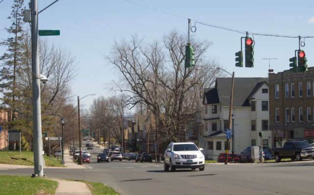
Then, you’re by Trinity College. The photo above shows the intersection with Summit Street, where there was a fatal motor vehicle crash a few years before. From this photo, you can see a few blocks ahead. You can see that the street still enables speeding. The college campus is on one side. Apartment buildings and houses are on the other side. There’s a little paint on the ground, but paint alone does not protect. Notice how the driver is casually blowing the red light. This happens every light cycle, just about.
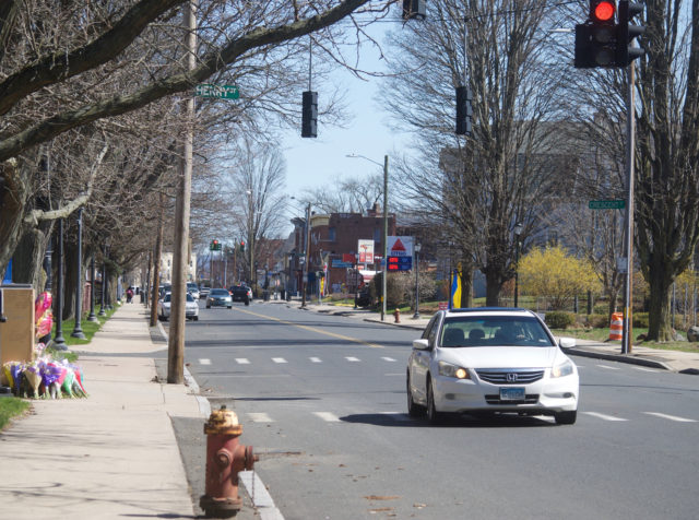
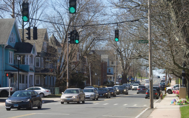
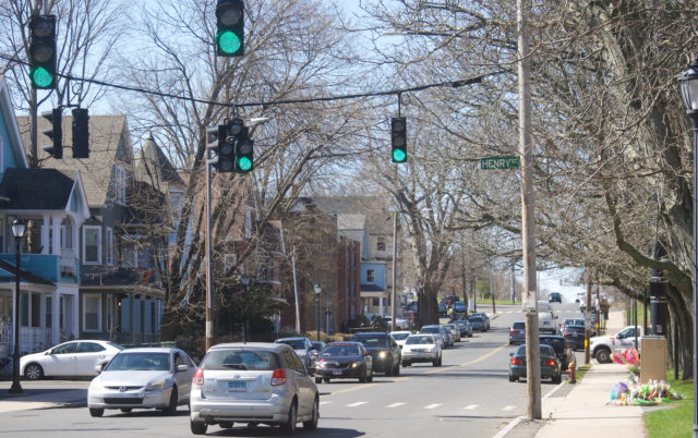
And then we have the intersection with Henry Street, where a coward struck three humans, killing one of them, and leaving the scene. In this photo, you can see another driver, casually running a red light. I stayed a few minutes by the death site, and saw multiple drivers choose to run the red light at New Britain Avenue and Henry Street. I watched people playing with their phones while behind the wheel. I saw all kinds of shit except meaningful action to improve the street.
If the death of a classmate and injury of two others less than 48 hours previous does not entice students to stop texting and driving, please tell me how you think banging the drum of individual responsibility is going to do a damn thing with the general public? Answer: it doesn’t. Stop pouring every effort into individual responsibility and start designing so that when people disappoint us, the results aren’t deadly.
This (immediately above and below) shows the Henry Street intersection, so you can get another perspective on that street design.
I wonder what Trinity College has been doing all these years to make streets safer for its students, but then, I saw Summit Street after it was recently repaved. They could have created bike lanes to narrow the road and reduce speeding, but they didn’t. On the other side of campus — Broad Street — there is ample room for protected bike lanes. Again, no effort made to protect people walking or cycling, or even driving. They don’t own those roads, but Trinity certainly has the money and the power to advocate for better, safer infrastructure.
The last shot I took on this segment of New Britain Avenue (below) shows the intersection with Broad Street. Just up ahead is where there was the fatal crash at Julius Street a few years ago.
WHAT NEXT
1. Correct people early and often when they dispense with exonerative language. Educate people that these traffic fatalities — neither the Trinity College pedestrian nor the Farmington & Sigourney motorist — are not accidents. They are crashes or collisions. Insist that there were things that could have done to prevent those deaths. Now that we have their attention, they are obligated to act. It will not bring anyone back to life, but it will prevent additional unnecessary deaths.
2. The next Complete Streets Task Force meeting is on April 11, 2022 at 12 PM. Show up and demand answers. Ask them why there are no sidewalks or crosswalks in the South Meadows where a pedestrian was killed in mid-March. Ask why New Britain Avenue has not been narrowed so that it is safer for all road users. If you can’t make the meeting, say it by email: grace.yi@hartford.gov and let the Complete Streets Task Force know you are not here to play around. Copy your politicians and other government employees on that message. In Hartford, here are some to get that message to: Michael.Looney@hartford.gov, Maly.Rosado@hartford.gov, TJ.Clarke@hartford.gov, Nick.Lebron@hartford.gov, Marilyn.Rossetti@hartford.gov, James.Sanchez@hartford.gov, Shirley.Surgeon@hartford.gov, Tiana.Hercules@hartford.gov, Joshua.Michtom@hartford.gov, and John.Gale@hartford.gov.
Don’t let anyone dazzle you with bullshit. Keeping people safe should be higher priority than street festivals.
Phone calls and in-person meetings are empty unless that person is also putting everything into writing!
3. E-Bike Day has been rescheduled to Wednesday, April 13 from 11 AM to 1 PM at the Capitol Building. Show up to test ride an electric bicycle or just to show your support.
Car-Free Diaries: Week 18
Instead of screaming into the void of Twitter, I bring you a weekly highlight reel of what it’s like going places in Greater Hartford when one is gloriously car-free. These posts are on a slight time delay because nobody needs to know exactly where I am when I am there.
HOW ARE YOU DOING?
I would like to revise my answer.
Recently, I was asked what question I am most frequently asked, in the context of not having a car, but later it dawned on me that it’s the question we are probably all insincerely asked: how are you?
Half-jokingly, I made a New Year’s Resolution to answer that question honestly when asked by people too lazy to try harder with conversation. I’ve failed to fulfill that even once, but I will keep making the effort.
How are you?
Just walked through the site of someone’s recent violent death.
There is windshield glass stuck in the sole of my shoe.
Over one week later, the glass remains scattered on the sidewalk.
How are you?
Simmering with trauma.
How are you?
Disgusted with the absence of political will to change dangerous conditions, knowing that the government and its players will cry poor, yet find the money when it comes to harassing people for loitering and panhandling. Hartford police managed to find resources to make 88 adult arrests for panhandling between January 1 through March 31, 2022. But money to make our most dangerous roads safer?
How are you?
Raging that the City of Hartford is pumping its energy into a watered down open streets scheme when it could be improving street design.
How are you?
About to backhand the next person who suggests that hi-vis clothing is the solution when we don’t mandate vehicles be painted in neon colors. I could walk down the street naked, wearing nothing but a garland of fairy lights, and someone would nearly run me down, shouting a fake ass apology out the window about how he “didn’t see” me.
These crashes are predictable.
Spend time as a pedestrian. Not just walking two blocks to the food truck downtown. Like, go half a mile, alone. Walking in a large group defeats the purpose.
Walk in areas designed to move people — particularly, non-residents — in and out of the city as quickly as possible.
Two days before the fatal crash at Farmington and Sigourney, I was walking home at lunch and narrowly missed just down the block from there, at Sigourney and Hawthorne. There is a slip lane here because it’s super important that nearby employees get out of Hartford and onto the Interstate ASAP.
The photo below shows the vehicle that was driven stupidly seconds before. The driver chose to blow the stop sign turning south from Hawthorne onto Sigourney Street. I was in middle of crosswalk at time. Right after that near miss, the driver was stopped at light in traffic. They risked my life for no time savings at all. If you can’t see, this is Connecticut plate BE35777.
How am I?
When I am killed by shitty road design and a bad driver, I demand that you all politicize the fuck out of my death. Miss me on the display of bouquets and candles. If I can’t walk down a street without dying, ain’t nobody else gonna get to use that street either. Drop large concrete blocks across the road. Can’t help yourself about those flowers? Get several of those massive flower pots from KNOX. But none of this thoughts and prayers bullshit. And if anyone dares call it an accident, I will return to haunt your dumb ass, and it won’t be cute.
DON’T NEED A DATA MAP TO KNOW WHERE THE PROBLEMS ARE
(But I’m gonna give you one anyway so you can’t pretend to not know, City of Hartford)
Farmington and Sigourney is one of the intersections I walk through multiple times each week as part of my work commute. When I saw there was a fatal crash here, my reaction was “of course there was.” A pedestrian was critically injured in this intersection in 2013; another killed in 1996. It’s where in 2020 someone sped through the intersection, crashing into another vehicle outside the dollar store.
It’s the intersection where I wrote about watching someone take a right turn on red from the left lane when people were using the crosswalk during the exclusive pedestrian phase. It’s where frequent crashes are known, even without looking at spreadsheets and maps, because there is poor maintenance at the southwest corner and debris sits long enough to be noticed.
When I walked by the fatal crash site at Farmington and Sigourney, about twelve hours after the preventable death, I was not remotely surprised by the amount of debris allowed to remain — a not-so-subtle reminder that this is outside of one of the city’s more “desirable” neighborhoods. The sidewalk was coated in broken glass. A foot-long piece from one of the cars was on the sidewalk halfway down the block. The lawn was soaked in fluids. What looked like the contents of someone’s trunk or back seat was strewn on the grass. Several 311 reports and over a week later, the broken glass remains.
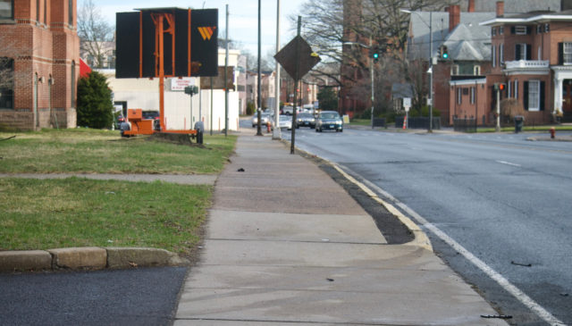
The car was cleaved by the pole at the corner — at least, that’s what the news photos showed. This is the pole where I stand to press the beg button to get a walk signal, because we are backwards and do not automatically program this at intersections where there are always people waiting to cross.
The thing is, once your eyes are opened to how there are patterns, you can’t close them again. You can’t walk around in some virginal mental state, believing these deaths are one-offs, “accidents.”
Rumor has it, when someone asked the Hartford Complete Streets committee what was going to be done following the recent fatal pedestrian crash in the South Meadows, a City of Hartford employee heading that committee was unaware of this death and suggested studies would need to be done before any action that seems stupidly obvious to those of us who regularly walk or bike, who know the city. You have high speed roads with no sidewalks and suddenly move a population to that area — people who are mostly walking or biking — do you need a study to indicate that if you do nothing else at all, you need to install some damn sidewalks?
I had all of this fresh in mind while repeatedly walking across the broken glass on Sigourney Street the past few days.
Our government — local, and otherwise — acts as if they do not know what is going on, yet they are collecting the data. They have the information. Is their intention to let it gather digital dust?
Bump that.
I’ve decided to make it my goal to strip the government of their excuses for inaction.
The screenshots that follow show crashes with injuries in 2020 and 2021. These are not all the crash sites with injuries in Hartford, only the most frequent ones.
I opted to show this, and not all crashes, because a little dinged bumper is not high priority.
I’ve also opted to omit the Interstate for a few reasons, mainly, that drivers crash their vehicles into other vehicles, or barriers, there, and that these are less to involve bystanders, pedestrians, cyclists, or people’s homes.
All of the crash sites featured are entirely predictable: intersections of roads designed to move vehicles more quickly than is reasonable.
The map above shows crashes with injuries at the intersection of Farmington and Sigourney. That’s eleven collisions resulting in injuries in two years.
The photo below is of Sigourney Street looking north towards the intersection with Farmington Avenue. It was taken during morning rush hour on Friday, March 25, 2022 — less than twelve hours after the fatal crash at the intersection. From the photo you can see how excessively wide the space is for motor vehicles, and how there is space on both sides for barrier-protected bicycle lanes. You might be asking why we don’t have these here. We’ll get to that another day.
Not mapped: the eleven crashes resulting only in property damage at this intersection in same time period. Crash here, you got a 50/50 shot of being injured.
I know I’m a broken record about this, but imagine if instead of cars, people were injuring themselves and each other with guns at this intersection. This would receive attention. It might not be handled the way we’d like it to, yet there would be acknowledgement of something amiss.
If you travel north, to the next major intersection, the situation is even worse. Look at the cluster. I zoomed in as far as was allowed, and can make out at least 17 crashes with injuries at Asylum Avenue and Sigourney Street. There were three crashes here that only resulted in property damage. Collide with another vehicle here, and you’re going to be injured, basically.
There is a school on one corner. (This is the intersection written about here)
A few years back, they had three crossing guards working this intersection at a time, and even then, drivers blew through the light.
Continue north on Sigourney Street and you’ll soon hit another high crash area: the intersection with Collins Street. There were at least nine crashes with injuries there:
New Britain Avenue is a piece of work. The City could expand the sidewalks on both sides and still have room for protected bike lanes in each direction. They could install raised intersections. A couple roundabouts. They could do a lot of things. For those most part, they’ve done nothing. There are hotspots all over this road, but the area by Trinity College is especially alarming, in part because there are many pedestrians in this area.
The intersection of Newington Avenue, Stone Street, and New Britain Avenue is not surprising. Newington Avenue is flat and straight; the posted speed limit is 30 MPH which drops to 20 by the intersection, but people drive far faster than that, no matter that there is a school at corner of Newington and New Britain Avenue.
New Britain Avenue is a four lane road. You’ll hear lots of griping about ATVs in this area “holding up traffic,” but it seems traffic could do with more holding up here, as there were ten crashes resulting in injuries at this spot over two years.
At Woodland and Asylum you have the combination of overly wide roads and frequent red light running. What you’ll find at each corner: middle school, hospital, medical facility, and State of Connecticut building. Some of the collisions here have involved more than two vehicles. At least one was a rollover.
Another obvious problem spot: Capitol and Broad. This intersection was revised a few years to be made worse. Instead of narrowing the intersection, the City of Hartford made it wider. This is where every single Sunday afternoon, without fail, two or more drivers decide to blow through the red light, going eastbound on Capitol Avenue to north on Broad Street — while I’m in the crosswalk.
I’ve watched people drive at highway speeds, particularly going south on Broad Street. This intersection is the poster child for traffic cameras, not only because of the constant violations, but because of the number of times I watch police chillin in their cars at the gas station lot, not stopping anyone for blatant moving violations. When we talk about needing enforcement, let’s make it clear that we’re talking about traffic cameras and not police.
A few blocks south on Broad Street is another cluster. Ten collisions with injuries in two years. There is a library branch on one corner of this intersection. This area enjoys a lot of pedestrian traffic. You do the math on how long before a kid gets seriously injured here.
There were another eight crashes at Park and Broad that only resulted in property damage.
Another serious crash leader is Garden Street and Albany Avenue, with nine crashes resulting in injuries.
There’s another seven at Albany and Woodland:
There were eight at Holcomb and Blue Hills:
Just as the redesign of Capitol and Broad did not make it noticeably safer, neither did the change at Wyllys and Jefferson, etc. I mapped this intersection with the corresponding disaster of Wethersfield/Main and Wyllys because to me it seems obvious that the same issue exists in both places.
This map shows what looks like sixteen crashes with injuries spread out over these two intersections.
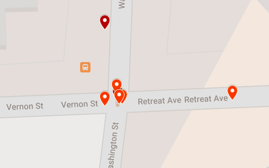
You might be asking yourself why there are a whole lot of serious crashes within one or two blocks of hospitals. The maps immediately above and below show sites within one block of a hospital
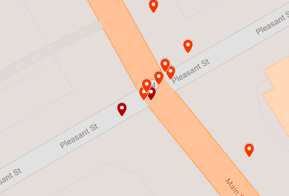
Then there’s Main Street and not-so-Pleasant Street, between a school and a stadium.
There’s Pulaski Circle, terribly designed and showing repercussions beyond itself:
Since this poor design is seemingly the only roundabout point-of-reference for many in the area, when they come over to the new roundabout at Russ/Sigourney/Park Terrace, you have people not grasping the concept of yielding to those already in the circle. When the feature first opened in 2021, the initial confusion was awesome. It slowed drivers way down. But now? You get people traveling at high speeds because the redesign did not sufficiently narrow the roadway, and not yielding to pedestrians or to vehicles already in the circle. There is not enough data yet for this site because it has only been open for a few months, but if engineers do not make changes if/when they install the bicycle “facilities,” I will not be at all surprised if it becomes a hot spot.
Already, there have been several crashes (this did not make it into recorded data) resulting in property damage: two newly planted trees were killed on New Year’s Eve. I also had the enjoyment of witnessing a speeding driver blow out his tire. He was too busy and important to stop for me in the crosswalk, and then immediately after passing, he ran into one of the new granite curbs. Pow!
The grassy spaces and sidewalk are continuously covered with hubcaps, bumpers, and other various bits of car debris.
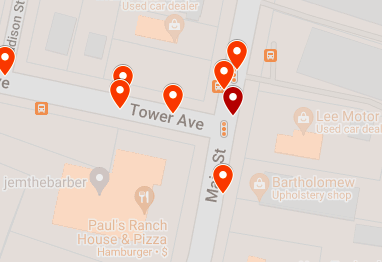
That brings us to Tower and Main, the site of a serious collision that made the news this morning. Two roads designed to enable excessive speeding. Who could’ve seen this coming? Anyone who has spent any time in this area, whether driving, taking the bus, walking, or riding a bicycle — and I’ve gone through this intersection using all those modes. Being on the bus is the only option that feels somewhat safe.
Eight crashes with injuries here in two years.
BUT WAIT, THERE’S MORE
It has not even been a full week since the last fatal motor vehicle crash in the city, and I’m waking up again to hear news of another — this time in the Northeast neighborhood. Later, the story changes. Someone misreported information. As police so callously put it, “the victim has not been pronounced yet.” Yet. Chances are, had it not been for that mistake, we would not have seen news coverage of it. Not for a collision on streets that aren’t used by those commuting in from the suburbs. It would’ve silently appeared in the database as a crash with injuries, known about only by those immediately involved, neighbors, and passersby.
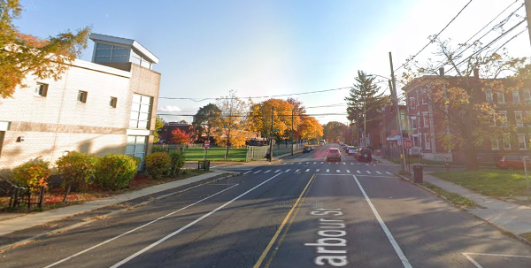
Since 2015, there have been three fatal car crashes on Barbour Street.
That’s the same number as on Albany Avenue for the same period — though 2 of the 3 crashes on Route 44 resulted in dead pedestrians. Chances are you’re more familiar with Albany Avenue than with Barbour Street, and even if you have occasionally driven the latter might be surprised that something seeming so residential would be this dangerous.
Look at the road design:

Looking south on Barbour Street, you see what appear to be reasonably-sized travel lanes…until we remember that paint does not protect and that if there are no cars parked in those empty spaces, it’s going to feel like a wider road, because it is. People drive faster when they feel like they have less to crash into. (Take the construction zone on Sigourney Street. The barriers were arranged to create a wide lane, so you still have people driving excessively fast. Move those barriers in so they only have a couple inches of wiggle room, and you’ll see those speeds drop.)
There’s all this space on Barbour Street marked for parking, but so much of it sits unused. Here’s a free idea for you, City of Hartford: Expand the greenspace and sidewalk on both sides of the street, so that most of the road is physically narrowed. Add street trees. You can leave some of the on-street parking, but I’d suggest 30% of less of what is currently available.
That could be done to so many streets. Start here. Invest in improving a street on which there are multiple schools, a bus route, a mix of residential and retail.
STILL MORE
Again.
Exhausting and predictable.
Another day of waking to read news of a fatal crash.
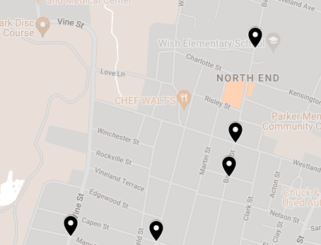
This one, on New Britain Avenue at Henry Street.
From memory, I knew there had been a fatal crash just a block away. That was a New Year’s Eve (3 AM, so technically, New Year’s Day) wreck, with driver ramming into a brick gate by the Trinity College entrance. That brick decoration, off the roadway, was never rebuilt and there continues to be a shrine.
Looking at the map above, which shows fatal collisions previous to 2022, I can see two other fatal crashes on New Britain Avenue. One from just before 11 PM in the summer of 2019, at the intersection of Julius Street. That’s two blocks east of last night’s crash.
A half mile west of last night’s crash was the site of another 2019 summer fatality. New Britain Avenue and Hillside Avenue. I do not love that I can recall the details of this without prompting. Sharlene Mansfield was crossing the street. Someone was able to — on a clear, dry day just before noon — ram into her because just about every street is built wide enough to accommodate a dump truck or something. The driver was able to operate the vehicle at high speeds, in the wrong lane.
We limit speed on e-scooters but not on cars. We allow sidewalks too narrow for two people to walk side-by-side on, yet have roads where swerving around is possible. Our priorities are messed up, but we get what we build for.
Last night, the roads were wet, but in the vast majority of fatal crashes in Hartford, the roads were dry. There’s hardly any information in the news, but as I’m getting ready for work I keep getting texts from friends all telling me the same thing: the victim is a Trinity College student. A few send me the internal Trinity College email in which this crash is called an accident.
Three young women crossing the street at night.
Women, we are told to walk with buddies so that we are not attacked at night.
Being in a group does not protect against someone speeding down the road, crashing into all of you, and killing one (Jillian Hegarty, 20), critically injuring another (unidentified woman, 19), and causing lesser physical injuries to the third (unidenitfied woman, 20).
That’s a distinction that must be made. The news tells us the nature of physical injuries. How does a person survive this without trauma?
It’s nice that the college is providing counseling to students. They’ll need it as they continue crossing the road where their classmate was run down. Do we talk about that, what it feels like to walk over someone’s death site every day? Many of us have been knowingly doing this already. We might not be young people with wide open futures, but we can tell you how it feels.
We know this will get media attention because the victim is the kind who will get sympathy from a public who generally does not care about pedestrian deaths. That attention does not inevitably create change. We’ve seen several young people killed while walking or cycling on Connecticut’s roads in the last few years, and what followed was typically a show of pitchforks and torches, going after the drivers, and not even well at that. In at least one of those more publicized fatal pedestrian collisions — the one in East Windsor where the town provides no sidewalks — the driver is still allowed to drive!
Two weeks ago, a 69-year old Hartford man was killed when the driver of a garbage truck struck him. In January, Yarillis Esteras, of Hartford, was killed when struck about five minutes from her home. About ten minutes into 2022, Michael Brown of Windsor was killed on Hartford’s streets; the driver of the vehicle that hit him did not remain on the scene.
Most pedestrian deaths go unnoticed. They shouldn’t.
There’s the “well, what then?” question I have been trying to answer.
Take the sadness or rage or disgust or disappointment you feel over a young person getting killed and hold that when you hear about any person getting killed. . . multiply that. Do something with it. Thoughts and prayers are not enough.
Yes, you.
Let the grieving families mourn without expecting them to spearhead action. Later, if they want to sue the pants off the City of Hartford or State of Connecticut for being negligent with their road design, support them.
Those not grieving a personal loss, you, have an assignment, and it goes substantially beyond hugging your own kids tighter.
Ask why we maintain the status quo of deadly roads. Shoddy design can be changed. Why aren’t be changing it? Ask the mayor. Ask city council. Ask Complete Streets. Ask the legislators. Ask the college, which has the political power to make change happen if they would like it to. Do not let them wash the problem away by calling it an tragic “accident.”
The Trinity College crash site is 0.1 mile from a police substation. The fatal crash last week at Sigourney and Farmington is 75 feet from a police substation. It’s obvious that police are not the answer, and that we can’t pin all our hopes on drivers doing the right thing. People will continually disappoint us.
You want to build back better?
1. Rebuild roads to prioritize safety of all, rather than the convenience of those in cars.
2. Require technology that limits speeds in all motor vehicles; the heavier and higher the vehicles, the more limitations needed.
3. Install speed and red light cameras. This makes enforcement predictable and does not allow for the face-to-face interactions that can either result in someone crying their way out of a ticket or escalating a situation to violence.
WALK OF SHAME
A normal person would probably spend her Saturday morning scrapbooking or something. I took the bus to Elmwood, and then walked most of the way home via New Britain Avenue, armed with my camera and a whole lot of focused rage. What you’ll see are photos taken in the 1.8 mile stretch between the town line and Broad Street.
This was not my first time walking it. Please. I’ve walked almost every street in Hartford, minus a handful of small residential streets. I already knew how bad it was, before that girl was needlessly killed on Thursday night/Friday morning, before looking at the data. I rarely walk more than a block or two of it because New Britain Avenue is, at best, unpleasant.
I don’t think others necessarily know. They see it from behind a windshield, but not as a pedestrian. I needed photographs.
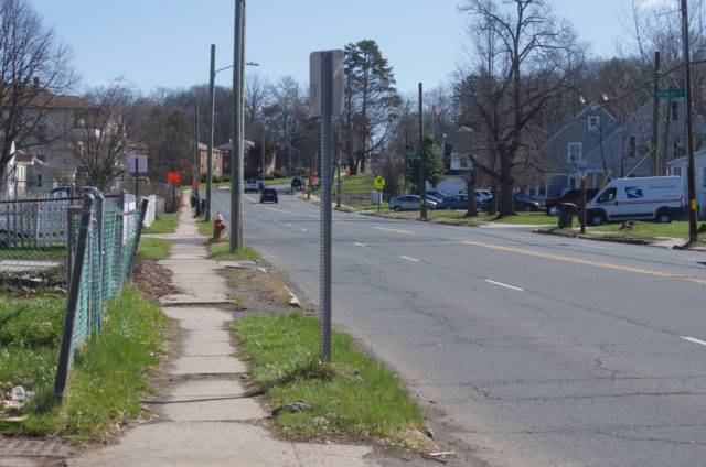
Not far from the town line, I encountered this, which might not look like much, but let me explain what you’re looking at: a narrow sidewalk being partially obstructed by a construction sign. Notice whose space has been determined sacred and whose can be taken away at any time.
It only gets more obnoxious from here. . . though it was plenty obnoxious in the West Hartford portion of New Britain Avenue too. (West Hartford, I’m coming for you another day.)
The sidewalks are narrow. You’re not walking side-by-side with your kid or large dog here. What does it mean about your place in the world when all of this space is given over to cars, but you get left with scraps, which are chipped away at with signs and other debris? I did not photograph the skunk carcass taking up part of the sidewalk.
Feel uncomfortable looking at that pic?
I hope so.
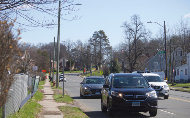
It felt uncomfortable being there, with very little space between me and speeding vehicles. I think about how people are driving 50 MPH and all they have to do is sneeze hard and swerve the wrong way. I should have recorded video, so you can hear the noise.
Is this the design one expects by an elementary school? Apartment buildings? Well, it’s the design we have.
The sign says 30 MPH, but road design says go faster!
This is the only modification I came across on New Britain Avenue between the town line and Broad Street, by the way. The flex posts and concrete barriers make it so people can’t fly from White Street directly onto New Britain Avenue and vice versa. Access still exists between the two, but drivers are forced to make a turn. Harvard Street was barricaded. One leg of Chandler Street was also blocked.
That made me feel hopeful, which was stupid because I should’ve known better.
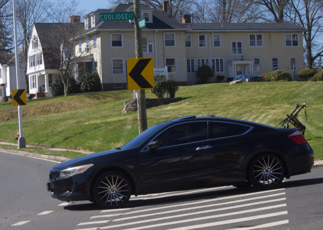
Up ahead, at the intersection with Coolidge Street, I had a bit of a disagreement with a driver. The entrance/exit from New Britain Avenue to Coolidge is exceptionally wide. I am unsure why. Are they accommodating oversized load trucks on the regular? It’s a long stretch to walk across. There’s no light, so no signal. People can glide right up there from New Britain Avenue without being forced to so much as tap the brakes before making the turn.
So, I wait my turn and after a driver (not pictured) proceeds through this intersection, I take my turn. There’s a dark car with very dark tints coming down Coolidge, but it’s a ways off and I’m crossing in the crosswalk.
You might think the driver would have slowed down, come to a stop, to yield to the visible and non-distracted person in the crosswalk. And you would be wrong. He kept moving right along.
I had to actually jump out of the way to avoid being hit, and then I cussed him out. He rolled down his window (this is how I know it was a dude and not like an octopus or alien driving the vehicle) to issue an empty apology, and I continued to cuss him out.
He claimed to not see me.
Was his head up his ass? Was he playing on his phone? Watching a movie? Stoned out of his mind? I was unimpressed by him. I let him know as much.
Once I got across the street to the sidewalk, I turned around and took out my camera. That’s the vehicle above with the bike rack.
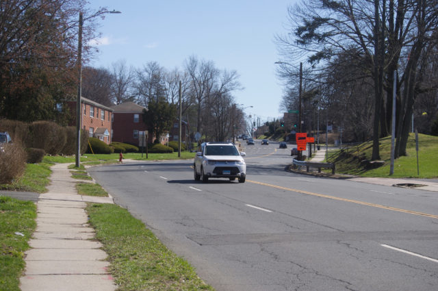
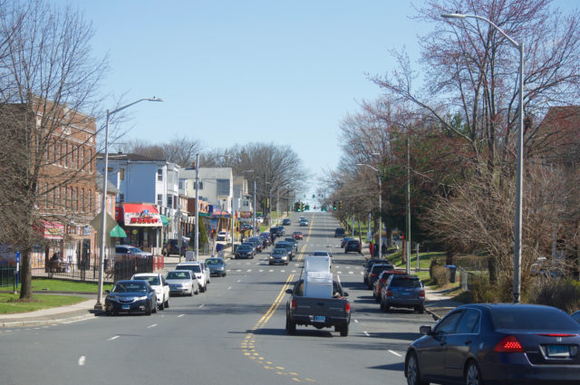
After that conversation, I was more than happy to spend money in one of the local establishments on the next block. The photo above shows what New Britain Avenue looks like after that turn at Coolidge. It’s a racetrack. The first set of traffic lights is at the intersection with Hillside Avenue, where a pedestrian was killed a few years ago. There are all these businesses, but the road is not safe for people.
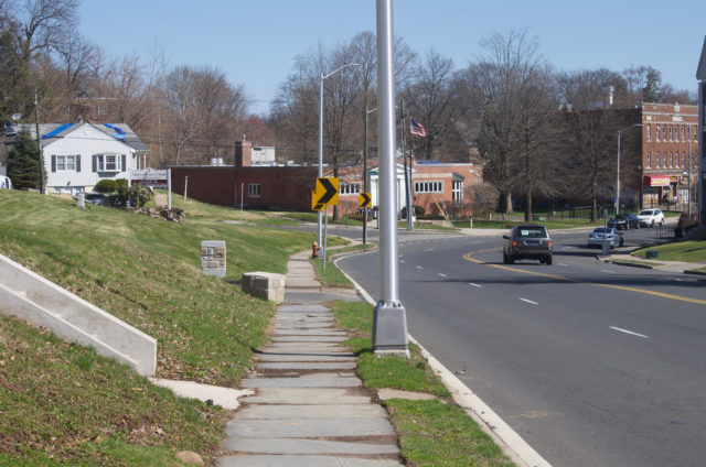
By the way, I chose to walk east on New Britain Avenue because that was reportedly the direction that the car was being driven in, the one that ran into three college students, killing one about 36 hours before this walk. I wanted people to see what this road looks like traveling in that direction.
The top of that hill is the intersection with Fairfield Avenue. There is no beg button, no exclusive pedestrian phase. You have to pray and move fast.
Then, you’re by Trinity College. The photo above shows the intersection with Summit Street, where there was a fatal motor vehicle crash a few years before. From this photo, you can see a few blocks ahead. You can see that the street still enables speeding. The college campus is on one side. Apartment buildings and houses are on the other side. There’s a little paint on the ground, but paint alone does not protect. Notice how the driver is casually blowing the red light. This happens every light cycle, just about.
And then we have the intersection with Henry Street, where a coward struck three humans, killing one of them, and leaving the scene. In this photo, you can see another driver, casually running a red light. I stayed a few minutes by the death site, and saw multiple drivers choose to run the red light at New Britain Avenue and Henry Street. I watched people playing with their phones while behind the wheel. I saw all kinds of shit except meaningful action to improve the street.
If the death of a classmate and injury of two others less than 48 hours previous does not entice students to stop texting and driving, please tell me how you think banging the drum of individual responsibility is going to do a damn thing with the general public? Answer: it doesn’t. Stop pouring every effort into individual responsibility and start designing so that when people disappoint us, the results aren’t deadly.
This (immediately above and below) shows the Henry Street intersection, so you can get another perspective on that street design.
I wonder what Trinity College has been doing all these years to make streets safer for its students, but then, I saw Summit Street after it was recently repaved. They could have created bike lanes to narrow the road and reduce speeding, but they didn’t. On the other side of campus — Broad Street — there is ample room for protected bike lanes. Again, no effort made to protect people walking or cycling, or even driving. They don’t own those roads, but Trinity certainly has the money and the power to advocate for better, safer infrastructure.
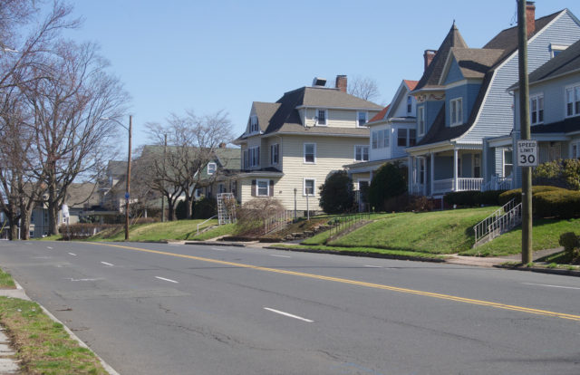
The last shot I took on this segment of New Britain Avenue (below) shows the intersection with Broad Street. Just up ahead is where there was the fatal crash at Julius Street a few years ago.
WHAT NEXT
1. Correct people early and often when they dispense with exonerative language. Educate people that these traffic fatalities — neither the Trinity College pedestrian nor the Farmington & Sigourney motorist — are not accidents. They are crashes or collisions. Insist that there were things that could have done to prevent those deaths. Now that we have their attention, they are obligated to act. It will not bring anyone back to life, but it will prevent additional unnecessary deaths.
2. The next Complete Streets Task Force meeting is on April 11, 2022 at 12 PM. Show up and demand answers. Ask them why there are no sidewalks or crosswalks in the South Meadows where a pedestrian was killed in mid-March. Ask why New Britain Avenue has not been narrowed so that it is safer for all road users. If you can’t make the meeting, say it by email: grace.yi@hartford.gov and let the Complete Streets Task Force know you are not here to play around. Copy your politicians and other government employees on that message. In Hartford, here are some to get that message to: Michael.Looney@hartford.gov, Maly.Rosado@hartford.gov, TJ.Clarke@hartford.gov, Nick.Lebron@hartford.gov, Marilyn.Rossetti@hartford.gov, James.Sanchez@hartford.gov, Shirley.Surgeon@hartford.gov, Tiana.Hercules@hartford.gov, Joshua.Michtom@hartford.gov, and John.Gale@hartford.gov.
Don’t let anyone dazzle you with bullshit. Keeping people safe should be higher priority than street festivals.
Phone calls and in-person meetings are empty unless that person is also putting everything into writing!
3. E-Bike Day has been rescheduled to Wednesday, April 13 from 11 AM to 1 PM at the Capitol Building. Show up to test ride an electric bicycle or just to show your support.
Related Posts
Public Water
The “Blizzard”
Hartford Museum Passport