The other day I got a message from a friend who was going to a nearby wooded area and had been a little nervous about being solo with no sense of direction. Knowing that feeling, I promised to remain on call for the next few hours in case she got hopelessly lost, though in an urban area, there’s only so lost one can get.
That should be a comfort to those starting out. You’re not heading into the desert where deadly critters abound and water does not. You aren’t going to an icefield. This isn’t even Case Mountain, though that recreation area in Manchester actually sees more use than Hartford’s most secluded spots.
An hour of walking in any natural area of Hartford will usually result in you finding a road, or at least a very obvious and predictable landmark. Here’s a little advice for navigating natural areas in Hartford, and then, how to appreciate them better.
NOT GETTING WILDLY LOST
- Get out the map!
- The easiest starting place is to look at an online map (you’ll probably go to Google Maps, but there are other options) in satellite or satellite-hybrid mode. Zoom it out just a bit and look for the large areas of green (as opposed to gray). Darker green means lots of trees; lighter green is grass. When you look at Hartford, you’ll see that the areas with the most green are Keney Park, Cedar Mountain, the Connecticut River and Park River banks, and then Elizabeth Park. Other city parks — Colt, Bushnell, Pope, etc. — follow.
- Using Google Maps for walking directions on street works well, but is less functional when it comes to trails. MapMyWalk is one program that allows for off-road route creation. (The function may exist in Google, but it’s not obvious) Be sure to click off “auto follow roads” because trails are not interpreted as roads in the program. Let’s say I want to know how long it would take me to meander from the Woodland Street entrance of Keney Park to Windsor Avenue, but I know I am going to sometimes walk across fields, I might use this to get some idea of how far it is. When I learn this is over four miles, I can decide if that seems realistic for me to do in an afternoon.
- At this time of year it’s much easier to plan outings because there’s so much daylight. It’s a different story if you’re trying to explore a new place in November. That’s the main reason, besides keeping adventures realistic for your ability, to map out a route in advance. If I know I have hours of daylight for playing, I’m honestly not looking hard at those trails beforehand. Phones have flashlights on them, which helps only if your phone is charged. If you’re new at this or on certain types of terrain, it’s definitely best to limit exploration to daytime.
- Also useful: GIS and MDC maps. Let’s say you’re worried about accidentally trespassing. A GIS map tells you who owns what. MDC maps show water better than Google Maps does. This will help you find small brooks, vernal pools, and wetlands.
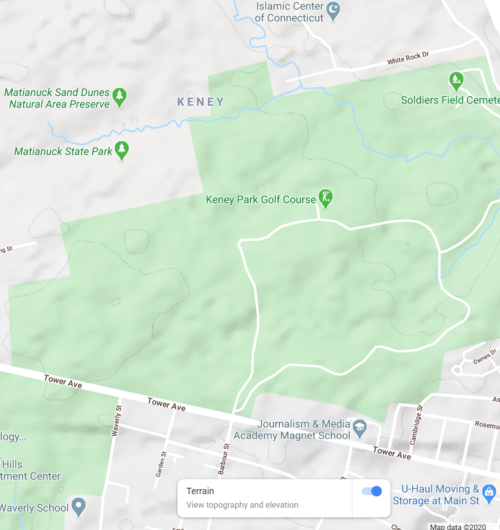
- If you’re not very familiar with where anything is in an area — like, let’s say you know how to get to work, the grocery store, a friend’s house, a few favorite restaurants, and that’s it — look at the map to see where things are in relation to each other. How are the green areas associated with other green areas? Might some run together and end up confusing you? Or extending an outing? For instance, check out the wooded area by Keney Park’s golf course. It blends together with Matianuck Sand Dunes Natural Area Preserve in another town.
- Try to memorize chunks of your route in advance so you aren’t looking at your map very often. Maybe take a screenshot of the map on the area you plan to visit in case wifi gets spotty.
- I’m not going to get deep into topographic maps because this is not a major concern in Hartford. If you put Google Maps in “terrain” view you will be able to see some inclines and depressions. A very insufficient explanation: more lines close together = steeper.Take a look at the variation within one part of Keney Park. Some changes in elevation, but unless you’re speedwalking or its already 90° out, you probably won’t sweat.
Compare that to Cedar Mountain, where it’s a little more demanding. There are hills within Cedar Hill Cemetery (name is a clue), but on the other side of it where there’s just gray, that’s even steeper.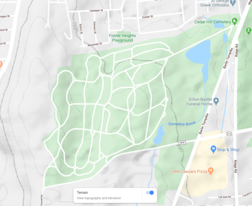
And compare that to Talcott Mountain outside of Hartford. Look at all those lines! That’s a steep incline.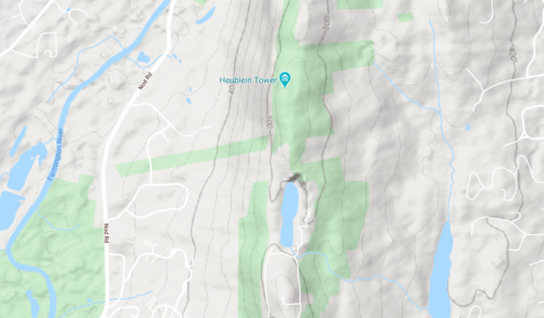
REI actually provides detailed explanations for how to use topographic maps and a compass. As for a compass, you probably have one already on your phone. - For urban exploration (i.e. not the Mojave Desert) I personally skip the compass and stick to landmarks. An easy one: rivers. If you head north from Charter Oak Landing, the Connecticut River with be on your right. Unless you cross the river (Charter Oak, Founders, or Bulkeley Bridge) or turn around, it is going to remain on your right. If you get to the train bridge and turn around, the river will be on your left the entire walk south.
- Have a bail-out buddy if you’re going alone. This is a friend/family member who you know will (1) check phone calls/texts that day (2) come through for you if you twist an ankle, get hopelessly lost, or have minor drama caused by not bringing enough snacks. Let them know where you plan to go and check in when you’re back. Personally, I think this is smarter than broadcasting on social media because when many people get the same message, there’s often the assumption that someone else has already stepped up. A small group text is going to be more helpful, I think. Plus, you’re 500 closest friends probably don’t need to know your every move. My messages to friends usually go something like this: “Heading out to wander Cemetery Brook. If you don’t hear from me by 2 PM, avenge my death!” The risk is not extreme in this area, but there is risk in everything.
- Three trial runs, from simplest to most challenging:
- Riverfront walk: The paths are obvious and once in the woods, there are markers when more than one trail is offered. You will basically be wedged between I-91 and/or the dike, and the Connecticut River.
- Cedar Hill Cemetery: lots of small roadways that can be confusing but they have a cemetery map available. Make use of landmarks like the flag pole, pyramid monument, large pond, and Cemetery Brook. There are large open fields and wooded areas at Cedar Hill Cemetery — go find turkeys and deer.
- Keney Park, Windsor Avenue or Tower Avenue entrance: This is a heavily wooded part of the park with multiple trails and old carriage roads. If you find yourself in a sand dune that is not part of the golf course, you’ve landed in Windsor. There is a ravine (careful!), vernal pools, and the remnants of an old zoo.
LOVING WHAT YOU’RE SEEING
It often feels that there are a million things competing for our attention, most of which are on the 4X5″ device we carry in our back pocket. With readily available distraction, it can be hard to really see what is around us. When I go camping, I remove social apps from my phone so that I’m not even tempted. Uninstalling and reinstalling apps daily, though, is not as practical, so here are other ways to trick yourself into being where you are (rather than having a fragmented experience):
- Meet your basic needs before all else: can you focus when you’re hungry, thirsty, and you have to pee? Not well, probably. Two of those three are not hard to manage: pack a snack and bring water.
- Meditative walking: What image comes to mind when people talk about meditation? Someone cross-legged in a room blasted full of incense? Mediation-in-motion is more interesting and doable for me. This works by taking a few minutes (or moments, whatever you can do) to close eyes and take slow breaths. Then, pay attention to how the ground feels under your feet. Hold on, open your eyes back up first before moving too far! Then, notice what is around you. As you start thinking about other things, just refocus.
- Try silence: This is much easier to do alone than with others who will probably try to chat because we’ve been socialized to avoid “awkward silences.” Turn the phone volume off, including vibrate mode. Skip the music. Don’t feel the need to do this every time, but it’s amazing what one or two hours of silence can do for a person.
- Stopping to smell (and see and listen to) the roses: At time of publication, there are plenty of literal roses to go smell — Elizabeth Park, Windsor Avenue entrance gate to Keney Park, Riverfront walk, neighbors’ yards. We live in a time of sensory overload, and it seems we end up not using any to their potential. Since it’s rose season, why not start there. Take time to look at just one rose bush (to start). What do the colors remind you of? Are the flowers tight like fists, or casually and wildly blooming? Do the petals look waxy? Translucent? Soft? Is the smell cloying? Gentle? What sound is made when a breeze passes through? Take time to tune into that one bush, then move on. Next time you are in the woods, spend that time observing one tree. At a pond, one cluster of cattails. Do you focus like this on an entire outing? No! But doing this once or twice will help you to tune in.
- Take your shoes off: If you can see that there is no broken glass, go for it. Watch out for poison ivy, rocks, and tree roots.
- Scavenger hunt: Set little goals/intentions for a walk. Maybe on this outing you’re hoping for woolly bears. Next time, look for trees with weird growths. See how many red birds you can spot. For those who need to check boxes, this can make relaxation feel less like you’re slacking off.Go have fun!