Besides looking at the fatal pedestrian/cyclist crash data statewide in 2020, I was tracking all collisions with pedestrians/cyclists in Hartford.
Except for first responders and hospital workers, it seems unlikely that the general public has an accurate understanding of these collisions’ frequency. Why would they? Few pedestrian crashes (that is, drivers striking people outside of vehicles with their cars) make the news unless the victim died or is likely to do so in the near future. Even the horror of that is veiled in more innocuous language like “critical condition” or “taken to the hospital with head injuries.”
Before I say too much, take a look at this interactive map. It shows where drivers struck pedestrians and cyclists in Hartford in 2020. The pins do not always represent one person; on several occasions, multiple people were hit by one vehicle. That information alone is disturbing for those of us who have ever joked with other pedestrians that there is power in numbers and surely the drivers will stop instead of wreck their cars on two or three people walking together. Your odds might improve, but it’s not a guarantee.
Observe where there are clusters of pins. What do you know about the large areas where there are no or very few pins to be seen?
As you keep in mind that for 10.5 months of 2020, Connecticut was in one lockdown phase or another, pay attention to the dates. You might expect a steep drop off in crashes in mid-March, but that was not what happened, and this information was available early into the pandemic. Fewer office workers may have been commuting to their jobs, but drivers were still crashing cars — often at higher rates of speed able to be obtained because the roadways were emptier. Add to this the folks experiencing existential dread, increasing substance use, and having nothing in particular to do at a time when gas prices encouraged misuse of resources. . .combined with an obvious sharp decrease in police enforcement before* the widespread call for restructuring law enforcement agencies — that’s a recipe of trouble.
For anyone who wants to call Hartford a ghost town, I have to ask them to explain how so many people have been hit by cars if nobody is here. Although there was a decrease in collisions in downtown and around a few major employers in Asylum Hill, people were still being hit by inattentive drivers during the pandemic months.
While there were fewer pedestrian crashes in 2020 than 2019, the number is not enough to be excited about given the circumstances, and there was actually an increase in fatalities.
When you look at the data from 2016-2020 mapped together, there is more opportunity to observe patterns. It’s much harder to use the a-word — accident — when poor design, which enables poor driving, is undeniable.
What do these maps tell us, and what information is not here?
The crashes shown here do not represent every time a pedestrian or cyclist has been hit. I was grazed twice in the past two years — both times while in a crosswalk when all traffic lights were red and I had the indisputable right-of-way. Summoning the police either time would have added more hassle and accomplished nothing from my perspective, as it was highly unlikely either driver would have stayed on scene and/or received a ticket for failure to yield and improper backing. From conversations with other cyclists and pedestrians, I know this is not my own rare experience.
The way injuries are described on crash reports (and subsequently when information from those reports is entered into databases) is also. . . weird. To me, a minor injury is getting tapped. It’s a light bruise or a scrape. It’s a trip to the drugstore for antibiotic ointment and a bandage. It’s the kind of injury that I would equate with the incidents that are largely going unreported.
But, that’s not what is meant on the crash reports. Police decide how to categorize the injury, and since they are not medical professionals, this is problematic. Take for instance, my friend who was struck on Farmington Avenue last year. The original crash report described his injuries as minor. This was essentially determined because he was conscious and coherent. He was taken to the hospital. His physical injuries included a fractured tibial plateau, a broken toe, and a dislocated and fractured shoulder. He immediately had surgery so screws could be installed to repair damage to one leg. He remains in physical therapy, four months after the collision. In a few weeks, he’s scheduled for a shoulder surgery. As someone who lives alone and does not drive, there is an extra burden of finding appropriate transportation to medical appointments, and finding a friend who is willing to do the mandatory night-after-surgery babysitting of him, during a pandemic when it’s unlikely most of his age group peers will have been vaccinated yet. After following up with police, he was able to get the crash report description changed to more accurately reflect the seriousness of his injuries.
You can imagine how many cases like that are represented in each of these pins. The “minor injuries” that resulted in surgeries, putting the victim at risk of blood clots and other complications. Doesn’t seem so minor now, does it?
What else do we know from these maps?
We can see trends in age of who is getting hit. In 2020, victims ranged from at least age 0 to 84. (I say “at least” because there were several victims whose ages were not reported) Age zero? Yep. A baby inside a stroller was hit alongside its parent or guardian. Last year, 22 people age 44-48 were struck, while 11 in the 18-22 group were hit. For anyone curious, the ages struck most were 45 (seven people) and 47 (six people). Sending out some extra thoughts and prayers for my fellow Gen Xers!
No matter what year — pandemic or not — people of all ages have been struck by vehicles:
2016: ages 2 to 88, with two fatalities
2017: ages 5 to 79, with two fatalities
2018: ages 1 to 84, with nine fatalities
2019: ages 0 to 88, with four fatalities
2020: ages 0 to 84, with four fatalities
As for the fatalities from 2016 through 2020, victims have ranged from 23 to 88. These victims were frequently hit while using marked crosswalks; one was struck while in a driveway and two were struck while on the sidewalk. Two of these fatalities resulted from one collision. There were several other occasions where a driver ran into two people at once, causing the death of one half of the pair each time. One person was killed while riding a bicycle in Hartford, and as of time of publication, I still have heard nothing in the way of an arrest of whomever killed him.
Although not on the map, Hartford’s first pedestrian fatality of 2021 happened on Albany Avenue near Oakland Terrace last Friday (26 Feb 2021). The person who drove an SUV into Kedine Campbell, 32, fled the scene, leaving her to die. This happened on the stretch of Albany Avenue that has seen renovations in the last few years which were supposed to improve pedestrian safety.
Something else that can be learned by clicking through the pins is how many people were hit on their way to and from school.
Were it not for school crossing guards, the number of school kids getting hit would undeniably be higher. But the sheer number of adults — who move predictably and are easily visible to motorists by virtue of not being tiny people is what’s astonishing to me.
We also know where infrastructure is wanting based on clusters of pins.
Take a look at Park Street. There are always people walking along Park Street, day or night, pandemic or not, cold snap or heat wave. But you know what’s missing? No-nonsense pedestrian infrastructure. There are signalized pedestrian crossings at Park and Washington, and then again at Park and Park Terrace. Nothing in between! That’s a distance of 0.6 miles. That’s a walk of over ten minutes. There are crosswalks, but that’s it. People cross where they think it’s safest to do so. While the low-quality brick pavers are finally showing signs of being replaced, much of the Park Street sidewalk has been unusable for years by those with wheelchairs and other mobility devices. Madeline Feliciano was using her wheelchair in the shoulder of Park Street near Washington last year when she and a companion were struck by a hit-and-run driver. She died from her injuries.
You might ask how people are getting hit at intersections that have exclusive pedestrian phases. To that, I would ask a few questions back: How long does the pedestrian have to wait to get her light cycle? Does the pedestrian phase provide enough time for a person who moves more slowly to safely cross? Is there a raised median on which a person can stand if she cannot clear the intersection during the pittance of time given to pedestrians? How many vehicles routinely run the red light at this intersection? How wide is the road? Is the street narrow enough to require a driver to stop before turning, or is it so wide that he can just proceed around a corner without pausing to look at who he may hit when he turns his car?
Looking at this map, there are a number of other repeat offender locations worth noting. The locations are organized, more or less, by neighborhood, though some intersections straddle more than one neighborhood and certain streets of concern span several neighborhoods.
- Downtown
- Market Street in the area of Morgan Street is terrible for pedestrians. Too many lanes of too many drivers impatiently exiting or entering the Interstate, with what they deem a pesky piece of city in between. Though there are pedestrian crossing signals here, the wait is long and there are routinely motorists who blow through the lights.
- There is a similar problem at Trumbull and Main, and at North Morgan and Main. If the City is serious about developing the area they’ve dubbed DoNo (the northern piece of Downtown) then it needs to get serious about making it safer for pedestrians and cyclists — and not just those who are headed to watch a game at the stadium.
- Pearl and Main: This has an exclusive pedestrian phase, which is likely why there aren’t more collisions. For a moment a few years ago, a traffic engineer disabled the “scramble” and was rightfully met with fury. Like many other problem intersections, the roads here are too wide, encouraging speeding. At least one car blows through the red light every cycle, even though this is likely the busiest intersection for pedestrians in the city on weekdays. Narrowing the roadway with protected bike and bus lanes would help with traffic calming. Reducing the wait time for pedestrians would improve the situation too. This is by a bus hub and if you are about to miss your bus that only runs once an hour, the temptation to throw yourself into traffic rather than wait another minute and a half for the light is too great. (On CT Transit’s end, they have work to do on improving bus frequency)
- The Circle of Death: Officially known as Pulaski Circle, the faux traffic circle is hugely problematic because it was designed to move cars speedily. . . cars being driven on and off the highway. Technically, it’s a highway connector, but if it looks like a highway and people drive on it at highway speeds, then it’s a highway. Reason dictates that coming off a highway, roads would be narrowed significantly and drivers would be forced to stop before proceeding, to break them of the high speed and enforce the notion that they are now on city streets, with a major park nearby, not to mention numerous residential buildings. Instead, drivers are given no meaningful signal to drop down to 25 MPH and look for people using the road. In one of the collisions in this area, a cop was hit. How is a driver not able to see a police vehicle?
- South Green
- It’ll be faster if I just say which streets do not pose problems in this neighborhood, though on each of those I have experienced aggression from motorists while walking or riding a bicycle, so nevermind.
- The whole area around Barnard Park in South Green is obviously in need of attention. There are plans to finally fix this. What’s interesting is that the “every development is gentrification people” have been fighting traffic calming measures which would benefit the existing population, who already move around by foot and bicycle. I can’t even. Yes, we can all agree that it sucks that improvements don’t get talked about in any real way often until it looks like folks with money are going to move in — to a building that will occupy a very, very long vacant lot — but there’s a saying about cutting off one’s nose to spite the face.
- Morris and Wethersfield: There is no signalized crossing for pedestrians only at the intersection that links Colt Park to the rest of the neighborhood. This means waiting for several cars to blow the red light before crossing Wethersfield, while then dodging the vehicles usually turning left out of Morris onto Wethersfield.
- The Maple/Jefferson/etc. Intersection was redone a few years ago — not improved — and people are still getting hit here. Why? Because it was changed to facilitate movement of cars, not the safety of people walking or cycling. If you cross in the painted crosswalks like the traffic engineers want you to, it will take two light cycles to typically get where you are going. Can you imagine if drivers were asked to sit in this intersection for five minutes?
- Main Street from Buckingham to Park is one long block, with no mid-block crosswalk. There have been four reported collisions in that space.
- The intersection of Park and Hudson: in the early part of the 20th century, engineers wanted to turn Hudson into a highway. It was originally a narrow, very residential street. As homes were vacated, the road width was increased. Those engineers actually aimed for Hudson to be even wider than it is today. As a result, people drive at near highway speeds on this overly wide road. It narrows slightly at this intersection. The wait for the pedestrian signal is long, so most people do not awkwardly stand on the corner forever, waiting. It should also be said that there is a restaurant dumpster near one corner, making the wait especially unpleasant in warmer months. As a side note, the next exclusive pedestrian phase on Hudson is not until the intersection with Capitol Avenue.
- The area around and including the Hartford Hospital/Connecticut Children’s medical industrial complex sprawl. You would think that an industry supposedly aligned with injury prevention would work harder to prevent injuries on and immediately surrounding its own campus.
- Sheldon/Charter Oak
- The intersection of Wyllys, Columbus, and Charter Oak Ave has had five reported collisions and is a fatality waiting to happen. Wyllys-Columbus is built to move out-of-town commuters as quickly as possible, with more lanes than necessary and with what seems like laughable pedestrian and cyclist infrastructure considering the context. The intersection has an exclusive pedestrian phase, but the wait for that is long and it is hard to trust the driver zooming around the corner at 45 MPH is going to stop.
- That there are conflicts all along Wyllys Street should surprise nobody. You get what you design for, and in this case, people outside of vehicles were not even a second thought. . . more like a third or fourth.
- Clay Arsenal
- Main at Seyms and Florence: Seven collisions, including one fatality. Lots of people living in this area, with businesses people want to access. You know what’s not here? Painted crosswalks or anything else that helps pedestrians to cross from one side of Main Street to the other. Well, there’s a narrow raised median, but that’s it. You still have to struggle across two lanes plus a parking lane (so, really three lanes) on either side of the median. If you think this is bad, you should see what Main Street looks like when mapped for car crashes excluding those with pedestrians and cyclists! Yet, Hartford has done nothing to improve safety on this road.
- The intersection of Albany Avenue and Garden Street has had nine pedestrian/cyclist collisions, one resulting in a person’s death, in the last five years. Another pedestrian was killed at this same intersection in 2010. The nearby intersections of Albany and Edwards, along with Albany and Chestnut had pedestrian fatalities in 2015 and 1997 respectively; one of those collisions occurred while the person was on the sidewalk.
- Northeast
- Five Corners: Six collisions with pedestrians and cyclists in five years, including one fatality. This area gets a lot of foot traffic and is bound to see more as the Swift Factory is now back in use. There are painted crosswalks here, but there remains opportunity for something of a road diet.
- Main Street at Sanford and Nelson: Seven collisions; Main Street at Capen and Battles: Six collisions. Main Street is structured like and used as a highway-lite. It’s an alternate to I-91, and because it is excessively wide in all locations, drivers can achieve speeds that are not suitable in areas where people live and work. Because nothing has been done to improve the road conditions for pedestrians and cyclists, it’s safe to say that the powers that be view us as collateral damage. Our bodies, our lives, are the price to pay so folks in cars can zoom through with as little inconvenience to them as possible.
- Enfield and Greenfield: This intersection has stop signs in each direction and a bodega on one corner, so there is the expectation of foot traffic. Adding curb extensions and painted crosswalks would not hurt.
- Capen and Barbour: Capen Street is wider than necessary and the intersection at Barbour could be tightened up. This is the site of where someone drove a car off the roadway and hit three pedestrians.
- Capen and Garden: Just down the road, you have an intersection with retail on three of the four corners. Definitely not one of the worst spots in Hartford for walking and cycling, but relatively small changes could make this safer.
- Upper Albany
- From the city line to the intersection with Main Street, there were eight collisions with people riding bicycles on Albany Avenue in the last five years. Already in 2021, there was one pedestrian fatality on the “improved” portion of the road, raising a number of questions about the quality of these renovations.
- The intersection of Homestead/Walnut and Garden, which straddles Upper Albany and Clay Arsenal, has been the site of five crashes, with another one just outside the intersection. These have included people riding bicycles — correctly — and pedestrians, along with one who was pushing a stroller. Having cycled and walked through this intersection a number of times, this does not surprise me. People drive cars too fast and frequently ignore the stoplight. Homestead is used as an alternate route from Albany because it is less congested, so even with fewer pedestrians and cyclists on this road in general, it’s wholly expected that there are collisions.
- Blue Hills
- If you are wondering where a person is most likely to be hit while going to or from school, Plainfield and Granby is that intersection, with all three reported collisions being school-related.
- Aside from that, Blue Hills Avenue is really the problem spot in this neighborhood, especially at Harold and Boothbay Streets
- West End
- This is a neighborhood where the map quickly shows you the economic divide. Most of the collisions in the West End are in areas where residents rely on transit, bicycles, or their own feet to get them where they’re going.
- Farmington Avenue
- Sisson Avenue
- Parkville
- Park Street continues to be a frequent collision place for pedestrians/cyclists here — not just in Frog Hollow and South Green.
- Hamilton Street. This is another overly wide road. People choose to drive at unwise speeds on the portion between Hillside and New Park Avenue. There are exclusive pedestrian phases at the intersections with Bartholomew and later at New Park Avenue, but there can be a wait and you have to trust that someone isn’t going to barrel through the light. The one thing that surprised me was that there were not collisions near the railroad tracks; at the crossing, the sidewalk sort of vanishes and it seems far too easy for a motorist to drift over without noticing that the asphalt they’re one is the pedestrian lane.
- Asylum Hill
- Sigourney and Ashley: This is a densely populated area next to a small neighborhood park, yet it has numerous crashes including a fatality. The City is looking into some kind of traffic calming for Ashley Street.
- Farmington Avenue at nearly every intersection shows itself to be a problem. In the last year, a driver crashed a stolen car at the intersection, of Farmington and Sigourney, ramming a parked car; by a miracle, there was nobody standing at this corner waiting for the light to change. There is constant flow of vehicles in/out of the strip mall’s front parking lot at this intersection, and there are always pedestrians in the area, making it a spot more should be alert to. I’m not sure why they don’t reserve the front lot as handicapped parking only, as there is an expansive and always nearly empty lot behind the plaza on Sigourney Street.
- Frog Hollow
- The intersection of Park and Washington is an obvious problem. It’s overly wide, which enables speeding. The sidewalks have long been problematic — broken pavers that make the road a more practical option for pedestrians who require even surfaces. There is an exclusive pedestrian phase, but it takes awhile. If there are any plans to fix this intersection, which a person was killed near in 2020, I have not heard of them.
- There’s a little cluster at Park Terrace and Ward Street. There are several obvious reasons for this. One is that this is what would and should be a natural entrance to Pope Park. Another is that the road is overly wide, encouraging speeding. Another is that there is nothing to slow vehicles turning from Park Terrace onto Ward Street, so people take the turn without pausing to see if anyone is in the crosswalk. I should note that one of these collisions was the result of a dirt bike and ATV being ridden through Pope Park, then darting out into the street. That has been an ongoing issue in the park, with some riders looking out for park users, and others not even looking out for themselves.
- Broad and Russ has no exclusive pedestrian phase, and if crossing Broad, it’s hard to see what’s coming because of on-street parking unless you walk into the street or are perhaps a much taller person. The speeding is phenomenal, particularly vehicles headed south. There are two bodegas, a church, and a large apartment complex on this corner. The barricades on Russ Street, if they remain, will likely help this a little because it reduces traffic at one leg on the intersection, but there is so much that could be done to improve Broad Street and make it less like a suburban route and more like a road that a ton of people live on.
- Park and Broad is awful. It’s a major hub, but there is nothing in the design to tell you this. Like much of Park Street, there is no exclusive pedestrian phase, which means people are always trying to cross the street yet never really seem to have the right to do so. What worries me, and this is not the first time I’ve voiced this, is that this is where the Park Street branch of the Hartford Public Library will be moving. Is the library advocating for safer streets? I don’t know. They should be.
- Laurel Street. This is overly wide in many places, especially between Park Street and Capitol Avenue. This is one very long block with no mid-block crosswalks. The road should be like half the width it is.
- Behind the Rocks
- The place to get hit by a car in this neighborhood is Charter Oak Marketplace AKA the Walmart parking lot and the area immediately surrounding it.
- Flatbush, at least the residential portion away from Walmart, had temporary speed bumps installed last year. They were removed to accommodate snow plows, but should go right back in, where their presence dramatically slowed vehicular traffic.
- South West
- Between areas that are entirely residential and high percentage of residents relying on cars (rather than bike, bus, or their feet) for mobility, this neighborhood has relatively few pedestrian/cyclist crashes.
- There was a fatality on Hillside near New Britain Avenue, asking the question of how the roads are designed to allow such high speeds in a residential area.
- The intersection of New Britain and Newington Avenues is a concern. There is a school here, but nothing about the surrounding roads feels like this was designed to keep children alive. There is an exclusive pedestrian phase, which requires a long wait for the person on foot.
- South End
- The intersection of Maple, South, and Freeman has seen two reported collisions in five years — one fatal. The City has done nothing to improve this intersection since the fatality. The wait for the exclusive pedestrian phase is long, and it does not give enough time for all road users to cross in one phase. This is bizarre since it’s a prime connection between a major, popular park and residential streets. My recent experience of this intersection was finding that one corner (Freeman and Maple Ave) was impossible to access because the Rent-A-Center plaza had not plowed their sidewalk or curb ramp, providing zero access for pedestrians. I had to cut through the parking lot and then walk up part of the block before finding a driveway entrance I could exit from. This dumped me on what should be a slow road, but cars were whipping around the corner from Maple. Yes, to cross this portion of road I needed to “jaywalk” or go to the end of Freeman, cross at the top of the hill, and then descend. . .which nobody is going to do because that’s an unreasonable ask. When I reached the other side, I found that the property owner had shoveled their sidewalk, but not the curb ramp. When I finally got the pedestrian signal, I attempted to cross to Goodwin Park, but the City of Hartford had not cleared its curb ramp, so I had to wander in the street for awhile until finding an opening. This was all a week after the most recent snow storm.
- Franklin Avenue and Wethersfield Avenue, in the South End and other neighborhoods, have collisions at just about every intersection. In the period from 1995-2015, there were four pedestrian/cyclist fatalities on Franklin and two on Wethersfield. On either road, there are few exclusive pedestrian phases, and they are very far apart. Both are mixed use (residential and business) areas.
- Franklin and South: Four collisions at this intersection
- Franklin and Bushnell: Two collisions, one fatal in the last five years. Hartford has made no improvements to road since the fatality.
- Wethersfield at Adelaide to Bliss: six collisions on this stretch, with two fatalities in the last five years. Hartford has made no improvements to the road since those fatalities.
- Barry Square
-
-
- Wethersfield at Wawarme to Shultas: Seven collisions in this short stretch, including one fatality. Hartford has made no improvement to the road since that fatality.
- In 2015 a cyclist was killed at Wethersfield and Bond, and looking through old data, there is a clear pattern of pedestrian and cyclist deaths on Wethersfield Avenue. Exactly how many people have to die on this road before someone with the power to do so shows some guts and fixes the road? A Wethersfield Avenue traffic calming design plan is reportedly close to being completed, but then the question is (1) is this plan sufficient, and (2) how long will it take to implement? It seems that this may included the addition of medians and a barrier-protected bicycle lane.
-
-
- North Meadows
- This area of the city — I hesitate to call it a neighborhood — was not built up with pedestrians in mind, and receives relatively low foot traffic. Low does not mean none, especially considering that there are a few motels up this way and a few fast food restaurants. If you look at the infrastructure at Weston and Boce Barlow, it should not surprise you that people have been hit here. Painted crosswalks aren’t even on some legs of the intersection. It’s ridiculously wide. Basically, it’s aggressively anti-person. Plus, three of the four corners have car-centered uses. I understand that not every single intersection needs to be a perfect example of Complete Streets infrastructure, but, the average person should have a shot in hell of surviving if needing to cross the road. Even in industrial areas, someone should at least be thinking: “how does a driver who runs out of gas and needs to cross the road for assistance do this without getting killed?”
- South Meadows
-
- Like the North Meadows, this is more of an industrial area than anything else, but there are also people who live here and who walk and bike places, like the regional market. Sidewalks are sporadic, as are painted crosswalks. Crossing the highway ramps is terrifying.
-
Not much surprises me, but a few things on the map actually did. One was that multiple people were struck on Pratt Street. For readers unfamiliar with Hartford, Pratt Street has been intermittently opened for use by people, much more so in 2020 (and 2021) than 2019, but even so, even with cars banned a lot of the time in 2019, how were people still getting struck on a road that should say “drive slowly”? Backing up.
Another surprise? Concrete barriers were installed on Russ Street in 2020. That, along with the sometimes closed elementary schools nearby, no doubt had a role in the lower collision rate there, but that’s not the surprise. It’s that even with those barricades in place, just around the corner from there, an 83-year old man was struck near one of the two bodegas on the corner of Russ and Broad. Hartford’s approach to safety has been total hodgepodge. Decent when you’re covered, but the moment you move out of a targeted area, you’re screwed. If you’re only walking up and down Russ Street all day, great. . . but most of us will want to veer off in another direction at some point.
A few last observations. . .
- The place you’re most likely to get hit while riding a bicycle? That’s the road that changes names from Homestead to Walnut to North Chapel Street to North Morgan Street. There were 17 collisions with cyclists on this road in the last five years — many of which involved motorists running red lights and crashing into cyclists who were riding correctly. Three of these collisions happened at Woodland and Homestead.
- There were a handful of collisions with pedestrians involving drivers attempting to pass garbage trucks. While the report does not spell out that those hit were DPW employees, it’s not hard to put two and two together. How does a driver not expect workers to be out in the street moving cans near a garbage or recycling truck? How does a driver not see the employee who is likely wearing a hi-vis vest?
- Something I remembered after looking again and again at the crash maps is how a few years ago the idea of creating a “bicycle boulevard” on North Beacon was floated out in a Complete Streets meeting, and it seemed silly to me at the time, but I couldn’t put my finger on why. Now, having data and not just a hunch helps me put words to the problem. In five years, there was one collision on North Beacon; that resulted in possible injuries. The West End, north of Farmington, has had a total of four pedestrian/cyclist crashes in five years, all at different locations. Why would this have been anyone’s idea for a safety improvement starting place when Hartford does not have an unlimited budget? We were told it was because of the location next to a City park. Well. If you glance at Hartford’s other parks, you can see much more demand for a bicycle boulevard or any pedestrian improvements. Any of the roads around Keney Park — especially Tower Ave and Vine Street — are begging for renovations. Streets near Colt and Goodwin Parks also make a better case for themselves, what with the recent fatalities at Wethersfield and Wawarme, and at South and Maple. A three-year old child was killed in Pope Park’s driveway in 2011. So, if we’re looking for an appropriate place to start with street improvements near a park, I would suggest choosing one where there is much more proven demand.
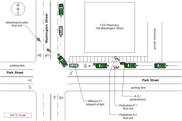
One last tidbit: I’ve included this crash diagram because I want readers to have a sense of one of the tools used to obtain the information about collisions. Creating the maps and this post, I looked through a thousand of these. When I did not have strong experience with an intersection or piece of road, I compared these diagrams to Google Street View, and in some cases, just went to the location itself to check out the built environment. This particular image is from UConn’s Connecticut Crash Data Repository and shows a fatal crash scene. From it, you can see the area of impact as compared to where the two pedestrians landed, and you can see where one victim’s wheelchair stopped, quite a distance away. The diagram shows that the driver did not remain on the scene. In addition to the diagram, I obtained information about this and other crashes by looking through the data itself, which reveals quite a bit, from the year, make, and model of vehicle involved (when known) to which EMS agency showed up and transported the victim.
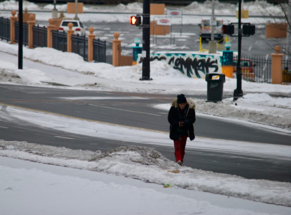
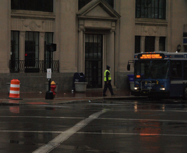
Photograph 1: Pedestrians have often been walking in Hartford’s roadways this winter because the sidewalks and/or curb ramps have not been sufficiently cleared of snow and ice, while the streets have been quickly maintained by the Department of Public Works. In Hartford, snow clearance from sidewalks is the responsibility of the property owner/manager, which makes for a patchwork of walkable and treacherous pedestrian lanes. Other northern cities have figured out better solutions.
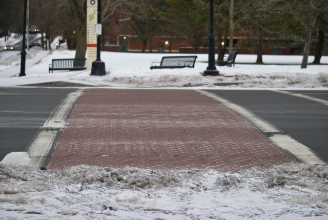
Photographs 2 and 3: Taken on 18 February 2021. The snow blocking curb ramps was from a storm on 7 February 2021. Photograph 3 shows two segments of Pope Park, which is owned and managed by the City of Hartford. I personally made several 311 complaints about these curb ramps. It was never addressed. For readers unfamiliar with the area, the sidewalk along these park segments is part of a major avenue, rather than being deep within a purely recreational area. People would be using this to reach a grocery store and laundromat, among other places of business.
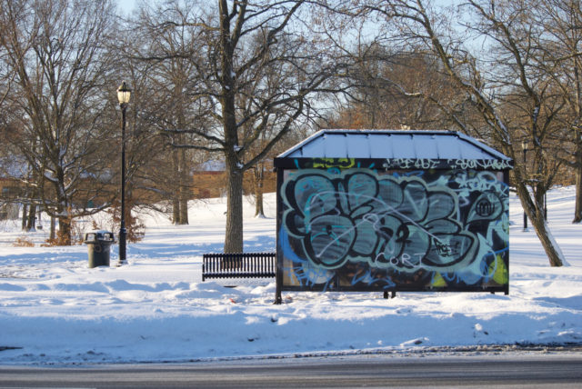
Photograph 4: This was taken on 20 February 2021, showing how no path from the bus shelter to the actual bus stop/road was established weeks following a snow storm. Pedestrians have had to either hop a snowbank or walk down the block where a curb ramp is cleared.
*If anyone wants to argue that cops only stopped enforcement after the protests in June, go back to the arrest logs in March and April and you’ll see how in the early days of the pandemic, police proved they could get by arresting only a few people each day in Hartford. It was a dramatic change. A regular weekday might see eight pages of arrests; suddenly there were days when the log was one or two pages. Since then, the arrests have gone back up, though still less than pre-pandemic on average. . . at least as far as adult arrests go.