The sloppy scribbles on this MDC map show you where the above-ground rivers and streams are in Hartford. Most of the city is within the purple. The blue doodles show brooks that have been almost entirely buried.
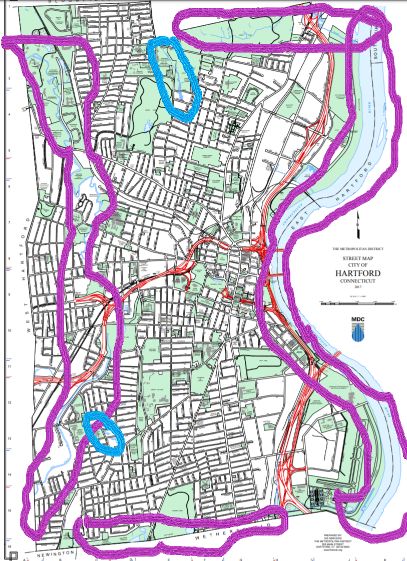
Go ahead and click on the image to get to the original map, to see more clearly which streets you can view Gully Brook from or where wetlands can be found or where there are even other streams that have been usurped by highways and industry.
As expected, the ground water quality in most of Hartford is not great. A 2018 water quality map has most of the city marked neon green, which means it’s “designated uses are industrial process water and cooling waters and baseflow for hydraulically-connected waterbodies and is presumed not suitable for human consumption without treatment.” A chunk is highlighted magenta, and if you know what’s there, you know what to expect — that spans the defunct landfill in the North Meadows. Blech. A portion is not highlighted at all, and is around the outer edges, the areas that were not taken over by factories or where housing was developed later on.
Anyway, put a pin in that idea. We’re here to have fun.

Walking/Biking
Want to see deer, bear, bobcats, coyotes? Visit rivers and streams. Even the maligned Park River’s South Branch corridor contains/supports life like turtles, snakes, deer, hawks, Bank Swallows, and Killdeer. It’s nice to go into the less populated parts of the state to explore, but there’s biodiversity right here too.
You can easily walk along about 60% of the Connecticut River in Hartford — the section from the trash incinerator south is mostly off limits. There are paved and gravel paths along parts of the Park River’s South Branch, and less maintained trails along its North Branch. The access road/driveway/whatever-you-want-to-call-it park road between Love Lane and Tower Avenue that goes behind Keney Park’s Waverly section gets you glimpses of Gully Brook. There are trails along Cemetery Brook. The Leadership Trail in Keney Park (Windsor Ave. entrance) gets you more live stream.
Don’t expect giant signs to greet you like are in place at the State Parks. These are not them.
Fishing
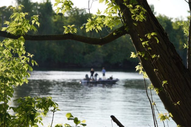
You can find somebody fishing the Connecticut River from the jetty in Charter Oak Landing or from the bank in Riverside Park north of the boat house any time during the season.
Keney Park stocks its pond (Edgewood Street). Circling the pond is a path with neat bridges, so you don’t need to be in the busier section right by the pond house.
Boating
Sadly there are no boat rentals yet, but if you have one you can launch from Riverside Park or Charter Oak Land.
Swimming
During that era people get all sentimental about, angry parents pressed for fences to go up around rivers, removing the likelihood that kids would be able to swim in natural bodies of water — unsupervised — and drown. Our ponds are not the most appealing. What we’ve inherited has been a place where swimming is either dirty and/or dangerous, or dependent upon public pools being open. That’s not a fun note to end on, but we need to notice the barriers that have been created by previous generations.
We’re finally seeing people in mainstream places acknowledge that there are barriers to the outdoors, and there is work being done to remove those barriers.