 Being super nerdy about transportation means taking in other cities through a particular lens, and in this case, it means having an idea of what amenities and development should be in place around major transportation hubs.
With a weekend of free train rides on the Hartford Line, I was able to check out New Haven and Springfield to see how they compared with Hartford.
New Haven
I have never been as smitten with New Haven as others in the area seem to be, but I wanted to give them a fair chance and look with fresh eyes. Getting off the Amtrak on Saturday, it was no challenge to navigate out of the station. I saw an advertisement for the Arts & Ideas Festival inside. It felt lively inside.
Once we exited the building, it got weird. Where to go? 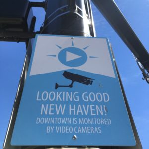
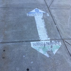
I did not notice any wayfinding signs immediately near the station, but saw worn markings on the sidewalk. There are plenty of signs letting us know that Big Brother is watching and those all appeared in new condition.
Bike New Haven‘s drop zone by Union Station is surrounded by serious-sounding signs promising that bikes would be removed if abandoned. This must be a widespread problem judging by how many alerts exist. There is not any signage indicating that this was a drop zone for Bike New Haven. You just had to figure it out or use an app.
Around the corner by the car parking garage is a large bike parking area which was getting plenty of use. The DOT wants to install another parking garage near New Haven’s Union Station, which is not forward-thinking for a number of reasons including how it 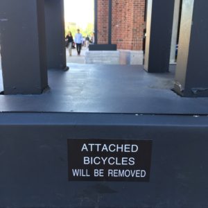 would expand what already feels like a sea of oversized structures in which one is drowning. The built environment is not welcoming. Nothing on the next few blocks feels human-scale. Brutalist buildings overwhelm what should be a more inviting entry to the city. The sprawling police station does not help matters.
Between a phone map and friend who was more familiar with New Haven, we were able to get to more visually interesting areas. These were not actually far, but going multiple long and boring blocks without any literal end in sight is an energy drain.
There were occasional bike lanes, disconnected from one another. A Contra-flow bike lane — one added to a one-way street — complete with a signalized light for bicycles, was adorable, though getting little use at the time; this likely changes when Yale is in session. Nearby, a large sidewalk space was ac tivated through the addition of portable tables. People were using them, even in the hot sun.
Bradley Street Bicycle Co-op is in a nice neighborhood and is inviting, with strawberries and other vegetation giving warmth to the shop. Inside, there are dozens of tagged bicycles; these were abandoned on Yale’s campus and removed. They must have less of a scrap metal economy in New Haven for bikes to stick along somewhere long enough to become a nuisance.
We were not the only people walking around the downtown area, where cigar and restaurant patios were full. On the green, the International Festival of Arts & Ideas attracted people of all ages. One of the festival’s activities — Box City — was attended by lots of children making a model city using boxes, paint, feathers, and random objects; part of the project involved kids learning about the permit process. Start ’em young! Throughout the weeks-long festival, free bike tours are offered often.
There are definitely things this place is doing well, but for all the pure adoration with which some in Hartford look at New Haven, I was expecting more.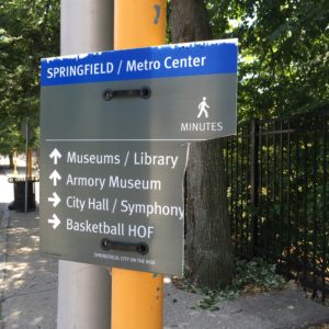
Springfield
Getting off the train in Springfield right now means walking across tracks, around construction vehicles and materials, and into a beautifully renovated Union Station. The restrooms are clean. The building still has a new smell to it. There is ample seating, along with a few standing desks with outlets. It’s well-lit. If you have to be stranded somewhere, you could do worse.
But outside, it is hard to know where to go next. We were already several blocks away before noticing a wayfinding sign, and that had its time estimate portion removed. By happy accident, we found ourselves on a lovely, tree-lined street. It looked like it had been extracted from Brooklyn. Nearby, we noticed stenciled and imprinted crosswalks, which used multiple colors and were not zebra-striped. At least one raised speed table was installed on a main arterial; the City of Hartford has said this can’t happen here.
Outside of this neighborhood, the downtown streets felt excessively wide. Crossing as a pedestrian was less 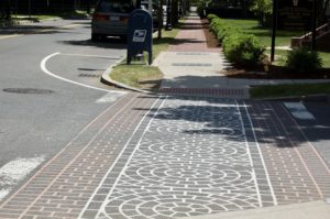 challenging than expected because of how few cars were traveling on the roadways on a Sunday afternoon. It was alarmingly quiet, with few bicyclists and pedestrians. We only saw a fair number of people again at the Springfield Museums, and that was fewer than expected. Was everyone at the road race? Had they all gone south on the free trains? Maybe there were amazing events happening elsewhere in the city, but they were not to be found in the downtown area.
There were some oddities. Pynchon Plaza, which on the map seemed to offer a direct, off-street route from downtown to the museums was gated and locked. An elevator shaft was boarded up. Vegetation was overgrown. There were no signs indicating that the area is being repaired, with the plan to re-open by the end of 2018.
Springfield seems to struggle to provide signage.
 Throughout the downtown, we saw that the signs mounted near pedestrian beg buttons kept getting smaller and smaller until finding one that was postcard-sized. Cute, but I’m wondering how this works for those with visual impairments. I also wonder if there is anyone who requires those signs and does not know what those buttons are for.
We knew there was a path along the Connecticut River and could find the general area, but saw no signs directing us. We thought there might be access thr ough a parking structure. Nope. We wandered around finding something that could connect us to the space we could actually see. Only after getting on the phone to find information about this did we locate an entrance on the map and piece it together. Good thing, because even at that entrance, there was hardly indication.
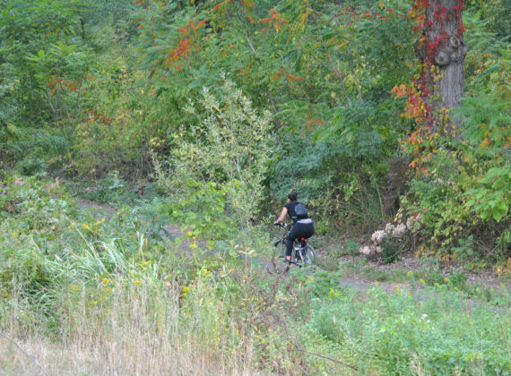
The Connecticut Riverwalk and Bikeway itself appeared 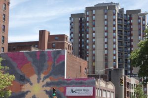 to be in a transitional phase. One segment had a new wooden fence. There wasn’t broken glass strewn everywhere. People were using the path, though not nearly at the rate one would expect on a Sunday afternoon when the weather was decent. We wanted to check out a park with a gazebo that looked nice from the path, but everything was gated. Again, no signs telling us what this park was or when it might be open. The Internet says this is the Pioneer Valley Riverfront Club. Walking in the other direction, we saw that the path is closed for a sewer project. It seems that there is a public park over there that maybe will be accessible someday.
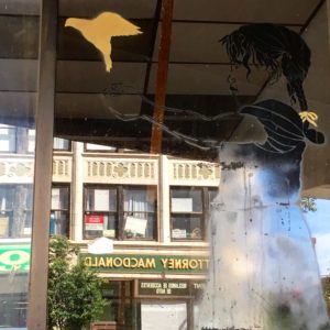
While the blocks around Springfield’s Union Station felt deserted, there was a fair amount of public art to add interest to the space between it and the downtown area. Utility boxes were painted, murals could be spotted on several buildings, and mirrored mosaics brightened a tunnel.
It’s not that there is nothing to do in Springfield. I’ve enjoyed the Springfield Museums, public art, and a restaurant, but it felt like the city was doing little to promote what it had to offer. So much seemed shuttered, and if there are renovations going on, I only learned about them from Google searches, rather than from signs on site explaining why something appeared to be in shambles. Much of our world has moved onto the Internet, but I did witness a man using a flip phone in Springfield — we should not expect everyone to have smartphones or data plans.
Hartford
Union Station has beautiful architecture, but there could be relatively low-cost improvements made between now and whenever the I-84 project forces the station to move. There is a cramped waiting area that needs better lighting. On the other side of the building is a spacious hall that contains no seating. It’s not obvious as to why seating has not been added to this underutilized space. There is — in the public area of the building — only one set of restrooms with few stalls. I can only comment on the conditions of the women’s bathroom: it needs love.
There are wayfinding signs right outside of Hartford’s Union Station, along with a restaurant and Bushnell Park. In this way, Hartford has an advantage over Springfield and New Haven because with no effort, there are a few attractive elements immediately upon exiting the train station. This makes it a little easier to overlook the mass vacancies along Union Place and Allyn Street.
On both days of the Hartford Line’s opening weekend, there were festivals in Bushnell Park — both visible from the train station. This seemed coincidental, but emphasized the need for all three cities along the Hartford Line to do better at programming events at locations where large numbers of people would be exploring on foot.
Rental bicycles were present around Union Station on both days, suggesting that LimeBike was intentional about redistribution to ensure that all the free Hartford Line riders would see them. All the user instructions are on the bikes themselves and we saw people investigating them. Bicycle parking can be found on the Spruce Street side of Union Station. There is not much in the way of bicycle facilities or intersection treatments in downtown Hartford, which may have been surprising for those coming in from New Haven or Springfield where the downtown areas had paint showing that bicycles belong on city streets. There are no bike lanes in downtown Hartford.
A few blocks from Union Station, we were able to casually find coffee shops keeping Sunday hours, despite being in the Central Business District. This is an improvement over just a few years ago. Cultural attractions, though open, could all do a better job of activating their patio/outdoor spaces to advertise and invite visitors in.
In New Haven and Springfield, I noticed few city buses. Maybe it was timing, but I saw several within a block of Hartford’s Union Station on Sunday when bus service is reduced. A number of crosswalks need refreshed paint and there is currently no crosswalk from Asylum Street and High Street to Bushnell Park. In-road pedestrian signs could be found on Asylum Street and Pearl Street.
If attempting to get to the Riverfront, a visitor stands a chance at finding it if coming through Bushnell Park. Anyone who has meandered a bit south or north of downtown will find entry points more difficult. If one manages to get to the I-91 pedestrian bridge in the middle of a parking lot, they can see a sign hinting that something is on the other side. Coming from the Colt area, you have to know a guy who’ll point you to the opening under the highway construction zone, next to a property surrounded by razor wire. Once on the path, though, the experience is enjoyable. Vegetation is kept under control. There is access to pavilions and boat launches. People make use of the path.
Verdict
Not one of the major cities along the Hartford Line is doing as well as they could or should in terms of urban design. New Haven needs to liven up the area around its train station and let people know that a fantastic number of restaurants and other attractions are in walking distance, even if they cannot be seen beyond the oversized buildings. Springfield needs more signs directing visitors to attractions; when parks and buildings are closed, tell the public that something better is in the works so that we aren’t left feeling like everything has been abandoned. Hartford has to get moving with safety improvements for pedestrians and cyclists, and address the vacant properties within a block of Union Station, considering breaking away from the nightclub use that has shown little staying power in recent years.
Christopher Brown
On my southbound CT rail trip on Sunday, I got off at the State Street station at a New Haven-based friend’s suggestion. I’d never used that station and it was great- so much closer to the NH green and nearby attractions! The timing of the return trip called for riding an Amtrak train, necessitating a longer, drearier walk to Union Station. I’m going to get off at State Street from now on if I’m not en route to points beyond New Haven.
Kerri Provost
Thanks for the tip. I don’t think people realize that not everyone is going to call up an Uber when they arrive, and that these walks can either impress or exhaust visitors.
Elisabeth
The walk from New Haven’s Union Station to the downtown area is grim and doesn’t feel particularly safe largely because there is no one around!
To me downtown Springfield has always (10+ years) felt like a dead zone on weekends. I can’t imagine that the new casino will do anything to improve that.
The location of Hartford’s train station and the iQuilt way-finding signage is far superior to that of our neighbors to the north and south. And even when nothing much is happening in downtown Hartford on weekends, there are still enough people around to feel safe.
Richard Nelson
Kerri, as always thank you for your postings. Christopher, thanks for the tip about State Street station. We love going to New Haven. When taking Amtrack we always had to get from the station to downtown and then back out to the station. The shuttle to Union Station runs from the Green every 20 mins. Never liked the area when walking either way too boring, hot/or cold, and a whole lot of nothing in-between. Our main attractions to New Haven is the Yale Art Gallery. What a wonderful place and Jock Reynolds has done a tremendous job in presenting their world class collection.
We never miss going to Group W Bench the little amazing shop way down on Chapel Street. We love taking the city bus out to the Peabody and then walking back to downtown. Lighthouse point is a quick bus ride away, bring a picnic lunch and spend part of the day. Hats off to the New Haven revolutionary Socialists, Anarchists, and Progressives who continue to be in the forefront of seeking change and building a new world.
Going to New Haven brings back many fond memories of the hay days of revolution when Tim and I were banned from the Yale Campus buildings for being outside agitators, when we lived in the Daggett Street Lofts and showed our art at the Sky Parlor Gallery on Chapel Street. Where we heard these wonderful words spoken by a Vietnamese supporter of the NFL, “The U.S has gone from truculence to barbarism without pausing to form a culture of its own.” Words that still ring true today.